
's-Heerenhoek
's-Heerenhoek | |
|---|---|
Village | |
 Street view | |
 Coat of arms | |
 's-Heerenhoek Location in the province of Zeeland in the Netherlands  's-Heerenhoek 's-Heerenhoek (Netherlands) | |
| Coordinates: 51°27′12″N 3°46′10″E / 51.45333°N 3.76944°E | |
| Country | Netherlands |
| Province | Zeeland |
| Municipality | Borsele |
| Area | |
| • Total | 9.09 km2 (3.51 sq mi) |
| Elevation | 1.7 m (5.6 ft) |
| Population (2021)[1] | |
| • Total | 1,975 |
| • Density | 220/km2 (560/sq mi) |
| Time zone | UTC+1 (CET) |
| • Summer (DST) | UTC+2 (CEST) |
| Postal code | 4453[1] |
| Dialing code | 0113 |
's-Heerenhoek is a village in the Dutch province of Zeeland. It is a part of the municipality of Borsele, and lies about 12 km east of Middelburg.
History[edit]
The village was first mentioned around 1750 as 'S Heerenhoek, and "means corner of the lord". It is located in the north-eastern corner of the Borsselepolder which was poldered in 1616. The lords refers to the lord of Schenge Castle in 's-Heer-Arendskerke.[3][4] 's-Heerenhoek developed after 1616 in a grid structure. In 1669, the village was devastated by fire and a new church was built in 1672.[4]
The Dutch Reformed church from 1672 was moved to Netherlands Open Air Museum in Arnhem between 1987 and 1988.[4] The village developed into a Catholic area from the 1760s onwards.[5] The Catholic St Willibrordus Church was built between 1873 and 1874 in Gothic Revival style and has a tall tower.[4]
's-Heerenhoek was home to 772 people in 1840.[5] The municipal council used to meet in the local inn. In 1881, it was outlawed to hold meetings in a locality which served alcohol. The problem was solved by separating a part of the inn and building its own front door. In 1892, a town hall was built.[5]
's-Heerenhoek was a separate municipality until 1970 when it was merged into Borsele.[6]
Gallery[edit]
-
 's-Heerenhoek, church
 -
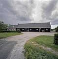 Farm in 's-Heerenhoek
 -
 Former clergy house
 -
 Farm in 's-Heerenhoek


References[edit]
- ^ a b c "Kerncijfers wijken en buurten 2021". Central Bureau of Statistics. Retrieved 19 April 2022.
- ^ "Postcodetool for 4453AA". Actueel Hoogtebestand Nederland (in Dutch). Het Waterschapshuis. Retrieved 19 April 2022.
- ^ "Heerenhoek - (geografische naam)". Etymologiebank (in Dutch). Retrieved 19 April 2022.
- ^ a b c d Piet van Cruyningen & Ronald Stenvert (2003). 's-Heerenhoek (in Dutch). Zwolle: Waanders. ISBN 90 400 8830 6. Retrieved 19 April 2022.
- ^ a b c "'s-Heerenhoek". Plaatsengids (in Dutch). Retrieved 19 April 2022.
- ^ Ad van der Meer and Onno Boonstra, Repertorium van Nederlandse gemeenten, KNAW, 2011.