
22nd Street (San Francisco)
 The switchback at 22nd Street and Collingwood. The steps to Diamond and 22nd are ahead in the Noe Valley area. | |
| Length | 2.9 mi (4.7 km)[1][2][3][4][5] |
|---|---|
| Coordinates | 37°45′17″N 122°25′40″W / 37.754782°N 122.427703°W |
22nd Street is an east–west street passing through the Noe Valley, Mission, and Potrero Hill districts of San Francisco, California. The street is discontinuous and exists in several sections: the main western section between Hoffman Avenue and the Bayshore Freeway, a segment from Vermont Street to Wisconsin Street, a short alley off of Missouri Street, and an eastern section from Texas Street to Pier 70. Below the elevated Interstate 280 and at-grade eastern section lies 22nd Street station, Caltrain's only station beneath ground level.
Steepness[edit]
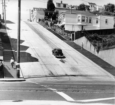
The street includes one of the steepest city blocks in San Francisco. In the 250-foot block from Vicksburg to Church Streets in the Noe Valley neighborhood, the city map shows a 79-foot descent along the south side of the street (78+1⁄2 feet (23.9 m) along the north side) for an average grade of just over 31%, about the same as the steepest block of Filbert Street in San Francisco.[6] (Both streets are one-way down; bottom of the 22nd St hill at 37°45′18″N 122°25′40″W / 37.7549°N 122.4279°W. A 1956 view seems to show a two-way street.)
Slow street and bicycle route[edit]
In 2022, the San Francisco Municipal Transportation Agency (SFMTA) board voted to add a section of 22nd Street to the city's Slow Streets program.[7][8][9] The slow portion will run between Chattanooga Street in Noe Valley and Bryant Street in the Mission District once implemented. As of April 2024, the SFMTA had not provided a timeline for the project.[7]
The SFMTA designated a similar section of 22nd Street as an east-west bicycle route, between Chattanooga Street and Potrero Avenue, on the agency's 2019 bike map.[10]
See also[edit]
- 22nd Street (Caltrain station)
- Baldwin Street, Dunedin — the world's steepest residential street.
References[edit]
- ^ "Google Maps". Retrieved 12 May 2022.
- ^ "Google Maps". Retrieved 12 May 2022.
- ^ "Google Maps". Retrieved 12 May 2022.
- ^ "Google Maps". Retrieved 12 May 2022.
- ^ "Google Maps". Retrieved 12 May 2022.
- ^ John Snyder (1999). San Francisco Secrets: Fanscinating Facts about the City by the Bay. Chronicle Books. ISBN 0-8118-2222-2.
- ^ a b "22nd Street Slow Street | SFMTA". sfmta.com.
- ^ Balakrishnan, Eleni (2022-12-07). "22nd to become 'Slow Street' as part of permanent city program". Mission Local. Retrieved 2024-04-09.
- ^ Parker, By Jordan. "S.F. Slow Streets are here to stay after transportation board approves plan". San Francisco Chronicle. Retrieved 2024-04-09.
- ^ "San Francisco Bike Network Map". SFMTA.
| Numbered streets |  | |
|---|---|---|
| North–south streets |
| |
| East–west streets | ||
| Diagonal streets | ||
| Alleyways | ||
This California road–related article is a stub. You can help Wikipedia by expanding it. |
This San Francisco-related article is a stub. You can help Wikipedia by expanding it. |