
Abbey Wood
| Abbey Wood | |
|---|---|
 Aerial view of Abbey Wood between Thamesmead (foreground) and Lesnes Abbey Woods. To the right Abbey Wood railway station | |
 Abbey Wood Location within Greater London | |
| Population | 17,700 (2021 census) |
| OS grid reference | TQ465785 |
| • Charing Cross | 10.6 mi (17.1 km) W |
| London borough | |
| Ceremonial county | Greater London |
| Region | |
| Country | England |
| Sovereign state | United Kingdom |
| Post town | LONDON |
| Postcode district | SE2 |
| Dialling code | 020 |
| Police | Metropolitan |
| Fire | London |
| Ambulance | London |
| UK Parliament | |
| London Assembly | |

Abbey Wood is an area in southeast London, England, straddling the border between the Royal Borough of Greenwich and the London Borough of Bexley. It is located 10.6 miles (17 km) east of Charing Cross. According to the 2021 census, Abbey Wood has a population of 17,700 (rounded to the nearest 100).[1]
Toponymy[edit]
The area takes its name from Lesnes Abbey Woods, located to the east, which once belonged to the monks of Lesnes Abbey.[2]
Development[edit]
The Abbey of St Mary and St Thomas the Martyr at Lesnes (or Lesnes Abbey) was founded in 1178 by Richard de Luci, Chief Justiciar of England. The Abbot of Lesnes Abbey was an important local landlord, and took a leading part in draining the marshland. However, this and the cost of maintaining river embankments was one of the reasons given for the Abbey's chronic financial difficulties. It never became a large community, and was closed by Cardinal Wolsey in 1525, under a licence to suppress monasteries of less than seven inmates. It was one of the first monasteries to be closed after the Dissolution of the Monasteries in 1524, and the monastic buildings were all pulled down, except for the Abbot's Lodging. Henry Cooke acquired the site in 1541 and it eventually passed to Sir John Hippersley who salvaged building materials, before selling the property to Thomas Hawes of London in 1632. It was then bequeathed to Christ's Hospital in 1633.

Abbey Wood railway station was opened in 1849, immediately to the north of the area now known as "The Village", built where Knee Hill became Harrow Manorway. Contemporary maps show Knee Hill as a minor track compared with a more major pathway through the centre of the existing woods.[3] The Village consisted of a dozen or so cottages, and two pubs, the Abbey Arms (next to the railway station) and the Harrow Inn (demolished in 2009).[4] The Harrow Inn which was located on the Kent side of Abbey Wood was the place where live bands would play in their hall; it was also the scene of a nightly migration as drinkers would relocate to the Abbey Arms each night, as Kentish closing times used to be 10.30pm whilst the Abbey Arms, which was in London, closed at 11 o'clock.
Abbey Wood was suggested as a site for a cemetery serving east London at a time of burial crisis in the capital. When the station was new, Edwin Chadwick proposed the closure of all existing burial grounds in the vicinity of London other than the privately owned Kensal Green Cemetery northwest of the city, which was to be nationalised and greatly enlarged to provide a single burial ground for west London, while a large tract of land on the Thames around 9 miles (14 km) southeast of London in Abbey Wood was to become a single burial ground for east London.[5] The Treasury was sceptical that Chadwick's scheme would ever be financially viable, and it was widely unpopular.[6][7] Although the Metropolitan Interments Act 1850 authorised the scheme, it was abandoned in 1852.[7]
The Royal Arsenal Co-operative Society (RACS) owned two farms on the hillside to the south of The Village; between 1900 and 1930, the RACE built the Bostall Estate. Once known as "Tin Check Island" after the Society's dividend system, and known locally as "The Co-op Estate", this has streets named after Co-operative themes (Alexander McLeod, the first secretary of the RACS, Rochdale, Robert Owen, Congress), a school and shops but, like much social housing of the period, no public houses. The housing is largely traditional of the "two-up, two-down" design, in distinctive yellow London brick, with gardens to the front and rear.[8]

Between 1955 and 1959, the London County Council built the Abbey Estate starting with one road south of the railway and later extending on the northern side on former Royal Arsenal marshland. Predominantly conventional brick houses with gardens, at first there were no shops or pubs, later equipped with a few shops and pubs together with schools and open spaces were added. Transport was non-existent at first until one bus, the route 180 was added after the building of Eynsham bridge. The estate was first used to rehouse people from Dockhead and Peckham then London's East End. The main through-road is Eynsham Drive.
In the mid-1960s,the Greater London Council began building the first phase of Thamesmead on more ex-Royal Arsenal land, north-east of Abbey Wood station. The original railway level crossing was replaced by a flyover.
Abbey Wood benefited from the opening of the DLR station at Woolwich Arsenal, whilst the next stage in the development of the area was the construction of Crossrail, a development tipped to encourage the growth of local house prices.[9] Crossrail, renamed The Elizabeth line, opened in 2022, with travel times of 11 minutes to Canary Wharf and 25 minutes to Bond Street.
The Greenwich ward of Abbey Wood has a population of just over 13,000, and its rail station sees over 3 million passenger journeys a year.
Demographics[edit]
According to the 2021 census, Abbey Wood has a population of 17,700. 35.4% of residents are aged 0-24, above the borough average of 31.3%. The largest ethnic group is White, making up 46.3% of the population, below the borough average of 55.7%, with the second largest being Black/Black British being 33.1% of the population, above the borough average of 21.0%. The largest religious group in Abbey Wood is Christianity, making up 51.7% of the population, with the second largest being No religion, with 24.5% of the population.[1]
Places of interest[edit]
Places of interest include the ruins of the 12th-century Lesnes Abbey and the adjacent Lesnes Abbey Woods, a Local Nature Reserve. Part of the Woods are designated as a Site of Special Scientific Interest called Abbey Wood, which has important Paleogene fossils. The ancient Bostall Woods & Heath. Bostall Woods (part of the South East London Green Chain) includes one of the few camping and caravan sites in London, which is owned and operated by The Caravan Club. The co-operative woods were also the site of the first camp for the Woodcraft Folk.
St. Michael and All Angels Parish Church was opened in a temporary building in 1905. A permanent church, designed by Sir Arthur Blomfield, was consecrated three years later, and the original building became the church hall. The Victorian Crossness Pumping Station is another notable local attraction.
-
 Ruins of Lesnes Abbey
 -
 Pond in Lesnes Abbey Wood
 -
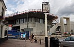 Construction of Crossrail station
 -
 The Harrow Inn, demolished in 2009, now scheduled to become the site of a residential building


Recreational facilities and parks[edit]
Abbey Wood has a number of parks and sports areas, including Bostall Gardens (play area, tennis courts and basketball court), Bostall Heath (cricket pitch, bowling green, orienteering, football pitch) and Abbey Wood Park (play area and football pitch). It also has a women's netball team Abbey Angels.[10] Abbey Wood Yoga offer yoga classes at St Paul's Academy, Bostall Gardens and pop-up events in and around Abbey Wood.
Notable people[edit]
This section needs additional citations for verification. (August 2015) |
.jpg)
Sir Charles Tilston Bright, the British electrical engineer who oversaw the laying of the first transatlantic telegraph cable in 1858, died in Abbey Wood in May 1888.[11]
Snooker champion Steve Davis lived in Commonwealth Way, Abbey Wood and went to Alexander McLeod Primary School and Abbey Wood Secondary School. Boxer Julius Francis went to St Thomas a Becket Primary School and Abbey Wood School, and Olympic runner Jennifer Stoute also went to Abbey Wood School. Playwright Jonathan Harvey also taught there. Kate Bush attended the convent school at the top of Knee Hill.
Robert Napper is one of Abbey Wood School's more infamous names. Convicted of two murders, one manslaughter, two rapes and two attempted rapes, Napper was in Abbey Wood from 1977 to 1982. He is most commonly known for his fatal attack on Rachel Nickell on Wimbledon Common in 1992 and the killing of Samantha Bisset and her four-year-old daughter Jazmine at Bisset's home in Plumstead in 1993. Napper was convicted of these crimes in December 2008, and sentenced to be held 'indefinitely' at Broadmoor Hospital. He is also believed to be the "Green Chain Rapist", who carried out at least 70 savage attacks across south-east London over a four-year period ending in 1994.
William Morris lived at the nearby Red House, in Bexleyheath, a house which was built for him by the architect Philip Webb. Morris regularly walked to Abbey Wood station, and a plaque just off Knee Hill commemorates this association.
Stewart Cochrane, a cruise ship bandleader, jazz musician, onetime member of NWOHM band Samson and author of Chindit Special Force Burma 1944[12] attended DeLucy infant/primary school.
Culture[edit]
Time 106.8, a licensed local radio station that evolved from an early cable channel - Radio Thamesmead - had studios on the Abbey Wood/Plumstead borders, and closed in April 2009. Abbey Wood also hosted London's first cable TV station, Cablevision, on Plumstead High Street, near Wickham Lane.
Education[edit]

St Paul's Academy is a Roman Catholic secondary school located in the area, on the original site of the Abbey Wood comprehensive school. It was previously known as St Paul's RC Secondary School, whilst located in Wickham Lane, before converting to academy status in 2005 when it moved to the new site.
Geography[edit]
Abbey Wood borders Thamesmead to the northwest, north and northeast, Belvedere to the east and southeast, West Heath.
Transport[edit]
London Buses[edit]
Abbey Wood is served by the following London Buses routes:[13]
- 177 from Peckham to Thamesmead
- 180 from Erith, Fraser Road to North Greenwich
- 229 from Queen Mary's Hospital to Thamesmead
- 244 from Abbey Wood to Queen Elizabeth Hospital, Woolwich
- 301 from Bexleyheath Shopping Centre to Woolwich
- 401 from Bexleyheath Shopping Centre to Thamesmead
- 472 from North Greenwich to Abbey Wood
- 469 from Queen Elizabeth Hospital to Erith
- B11 from Bexleyheath to South Thamesmead, Yarnton Way
- SL3 from Thamesmead to Bromley North
- N1 from Thamesmead to Tottenham Court Road (night bus)
National Rail[edit]
The nearest station is Abbey Wood for Southeastern services towards Barnehurst, Crayford, Dartford, Gillingham, London Cannon Street and Charing Cross, and Thameslink services towards Luton. The station became a terminus for the southeastern branch of the Crossrail-constructed Elizabeth line on 24 May 2022, providing services towards London Paddington and Heathrow Terminal 5.[14][15]
References[edit]
- ^ a b "Build a custom area profile - Census 2021, ONS". www.ons.gov.uk. Retrieved 18 March 2024.
- ^ Mills, A.D. (2010). A Dictionary of London Place-Names. Oxford University Press. p. 1. ISBN 9780199566785.
- ^ See http://www.ideal-homes.org.uk/greenwich/abbey-wood/map-abbey-wood-1870.htm Archived 18 November 2008 at the Wayback Machine.
- ^ See http://www.stmichaelsabbeywood.co.uk/history.htm
- ^ Clarke, John M. (2006). The Brookwood Necropolist Railway, Locomotive Papers 143 (4th edn). The Orchard Press. p. 8. ISBN 978-0-85361-655-9.
- ^ Arnold, Catherine (2006). Necropolis: London and its dead. Simon & Schuster. p. 160. ISBN 978-1-4165-0248-7.
- ^ a b The Brookwood Necropolis Railway. p. 11.
- ^ See http://www.kentarchaeology.ac/authors/006.pdf for a more detailed description of the building of the Bostall Estate.
- ^ Thelwell, Emma (5 October 2007). "Crossrail to create property hot spots". The Daily Telegraph. London.
- ^ "Abbey Wood Women's Netball Team". Abbey Angels. Archived from the original on 15 September 2017. Retrieved 15 June 2012.
- ^ Bright, Edward Brailsford; Bright, Charles (2012). The Life Story of the Late Sir Charles Tilston Bright, Civil Engineer : With Which is Incorporated the Story of the Atlantic Cable, and the First Telegraph to India and the Colonies. Volume 2. Cambridge: Cambridge University Press. pp. 435–436. ISBN 9781108052894. Retrieved 14 May 2021.
His comparatively sudden death occurred at early morn on Thursday, May 3rd, 1888, from failure of the heart, while on a visit to his brother, near Abbey Wood, in Kent.
- ^ Cochrane, Stewart (20 May 2000). Chindit: Special Force, Burma 1944. ASIN 0738820415.
- ^ "Buses from Abbey Wood" (PDF). Transport for London. Retrieved 26 February 2022.
- ^ "Booking Engine". ticket.southeasternrailway.co.uk. Retrieved 19 March 2024.
- ^ "Real Time Live Trains Board | National Rail". www.nationalrail.co.uk. Retrieved 19 March 2024.


