
Mount Coulthard
| Mount Coulthard | |
|---|---|
 East aspect | |
| Highest point | |
| Elevation | 2,645 m (8,678 ft)[1] |
| Prominence | 255 m (837 ft)[2] |
| Parent peak | Andy Good Peak (2,662 m)[2] |
| Isolation | 1.38 km (0.86 mi)[2] |
| Coordinates | 49°33′29″N 114°34′13″W / 49.55806°N 114.57028°W[3] |
| Naming | |
| Etymology | R. W. Coulthard (1875–1946) |
| Geography | |
 Mount Coulthard Location in Alberta  Mount Coulthard Mount Coulthard (Canada) | |
| Location | Castle Wildland Provincial Park Alberta, Canada |
| Parent range | Flathead Range Canadian Rockies |
| Topo map | NTS 82G10 Crowsnest |
| Geology | |
| Mountain type | Fault block |
| Type of rock | Limestone |
| Climbing | |
| Easiest route | Scrambling via NW slope[4] |
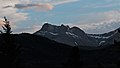
Mount Coulthard is a mountain straddling the border between Alberta and British Columbia in Canada.[3] It is part of the Flathead Range which is a subset of the Canadian Rockies. The mountain is set on the Continental Divide, in Castle Wildland Provincial Park. It is situated in the Crowsnest Pass area and can be seen from Highway 3, the Crowsnest Highway.[5]
Mount Coulthard is named after Major Robert Wilson Coulthard (born December 6, 1875), a prominent Canadian mining engineer. He was general manager of the West Canadian Coal Company, engineer at Crow's Nest Pass Coal Company from 1901–1908, and a Major with the 2nd Canadian Tunnelling Company.[6][7] The mountain's toponym was officially adopted in 1928 by the Geographical Names Board of Canada.[3]
Geology[edit]
Mount Coulthard is composed of limestone, a sedimentary rock laid down during the Precambrian to Jurassic periods. Formed in shallow seas, this sedimentary rock was pushed east and over the top of younger Cretaceous period rock during the Laramide orogeny.[8]
Mount Coulthard contains a 370 m (1,210 ft) long and 61.2 m (201 ft) deep cave on its northern face called Coulthard Cave. It was discovered in 1968 by Monica and Tammy Morris and has a 7 m (23 ft) in diameter entrance.[9]
Climate[edit]
Based on the Köppen climate classification, Mount Coulthard has an alpine subarctic climate with cold, snowy winters, and mild summers.[10] Winter temperatures can drop below −20 °C with wind chill factors below −30 °C.
Gallery[edit]
-

-
 Mt. Coulthard, northeast aspect


References[edit]
- ^ "Mount Coulthard, Alberta". Peakbagger.com. Retrieved November 3, 2022.
- ^ a b c "Mount Coulthard, Peakvisor.com". Retrieved November 3, 2022.
- ^ a b c "Mount Coulthard". Geographical Names Data Base. Natural Resources Canada. Retrieved 2022-11-03.
- ^ Andrew Nugara (2014), More Scrambles in the Canadian Rockies Second Edition, Rocky Mountain Books, ISBN 9781771600170, p. 182
- ^ "Mount Coulthard". cdnrockiesdatabases.ca. Retrieved 2022-11-03.
- ^ Place-names of Alberta. Ottawa: Geographic Board of Canada. 1928. p. 38.
- ^ Dave Birrell (2000), 50 Roadside Panoramas in the Canadian Rockies, Rocky Mountain Books, ISBN 9780921102656, p. 138
- ^ Gadd, Ben (2008), Geology of the Rocky Mountains and Columbias
- ^ Rollins, Jon (2004). Caves of the Canadian Rockies and Columbia Mountains. Rocky Mountain Books. p. 40. ISBN 0-921102-94-1.
- ^ Peel, M. C.; Finlayson, B. L.; McMahon, T. A. (2007). "Updated world map of the Köppen−Geiger climate classification". Hydrol. Earth Syst. Sci. 11: 1633–1644. ISSN 1027-5606.
External links[edit]
- Robert Wilson Coulthard: Google books
- Mount Coulthard: weather forecast