
Currency Creek, South Australia
This article needs additional citations for verification. (March 2013) |
| Currency Creek South Australia | |||||||||||||||
|---|---|---|---|---|---|---|---|---|---|---|---|---|---|---|---|
 Currency Creek | |||||||||||||||
| Coordinates | 35°27′14″S 138°45′30″E / 35.453872°S 138.758216°E[1] | ||||||||||||||
| Population | 443 (SAL 2021)[2] | ||||||||||||||
| Established | 1840 (town) 31 August 2000 (locality)[3][4] | ||||||||||||||
| Postcode(s) | 5214 | ||||||||||||||
| Time zone | ACST (UTC+9:30) | ||||||||||||||
| • Summer (DST) | ACDT (UTC+10:30) | ||||||||||||||
| LGA(s) | Alexandrina Council[1] | ||||||||||||||
| Region | Fleurieu and Kangaroo Island[1] | ||||||||||||||
| County | Hindmarsh[1] | ||||||||||||||
| State electorate(s) | Finniss | ||||||||||||||
| Federal division(s) | Mayo | ||||||||||||||
| |||||||||||||||
| |||||||||||||||
| Footnotes | Adjoining localities[1] | ||||||||||||||
Currency Creek (postcode 5214) is a township and locality in South Australia on the western shore of Lake Alexandrina about 6 km north of Goolwa, beside a seasonal stream bearing the same name – Currency Creek – which flows into Lake Alexandrina. The locality includes the headland named Finniss Point which separates the mouths of Currency Creek and the Finniss River.
History[edit]
Parts of Lake Alexandrina near to Currency Creek were initially explored by Charles Sturt in an open boat in 1830 but he did not sight the creek.[citation needed]
In December 1837, while exploring the Lake and Murray Mouth looking for other outlets to the sea, a party led by Thomas Bewes Strangways and Young Bingham Hutchinson discovered the waterway while using a whaleboat borrowed from the Encounter Bay fishery.[6] The whaleboat, which in September 1837 had been sold off the schooner Currency Lass at Adelaide, bore the same name as its mother ship, and they named the creek in honour of this boat.[7] They reported on the good grassland in the area and its potential for agriculture.
The township was surveyed in the Currency Creek Special Survey of 1840 but it never really thrived due to the nearness of Goolwa. During the later 1800s the district supported many market gardens along the fertile river flats. The Currency Creek Cemetery contains many historic gravestones. It is notably large compared to the township for the reason that it has serviced the entire district for well over a century.[citation needed]
.jpg)
Boundaries for the locality were created on 31 August 2000 for the "long established name" and include the Government Town of Currency Creek[1]
Wine industry[edit]
Currency Creek lends its name to a wine region that stretches from Port Elliot in the west, to Lake Alexandrina to the east, and includes Hindmarsh Island.[8] The main grape varieties grown are Chardonnay, Sauvignon blanc, Cabernet Sauvignon and Shiraz. Vineyards were first established in the area in 1969, with the region producing its first vintage in 1972.[9]
Currency Creek Arboretum[edit]
The Currency Creek Arboretum is named after the nearby geographical feature and town. Founded privately by Dean Nicolle and supported by volunteers, it is being developed as a specialist eucalypt (Angophora, Eucalyptus and Corymbia) arboretum with its main purpose being research into Australia's most dominant natural group of plants, the eucalypts.[10]
See also[edit]
Gallery[edit]
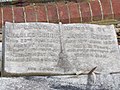
Memorials to River Murray pioneers at Currency Creek cemetery include:
-
 Captain Wolter
 -
-
 Captain Shetliff
 -
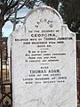
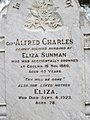
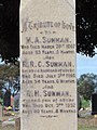 Captain Sunman
 -
-
-
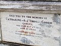
 Jeannie Goode
 -
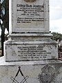
 Georgina Johnston
 -
 Stephen Goode
 -
 Shirley Goode
 -
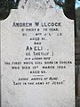 Andrew Willcock
 -
 Captain Sunman
 -
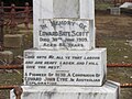
 Edward Dashwood Scott
 -
 Edward Bate Scott
 -
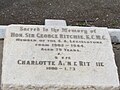
 Capt. Ritchie
 -
-
 Elisha and George Bennett
 -
 Herbert Armfield
 -
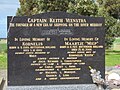 Keith Veenstra


See also Murray–Darling steamboat people
References[edit]
- ^ a b c d e f "Search results for "Currency Creek, LOCB" with the following datasets selected – 'Suburbs and Localities', 'Counties', 'Government Towns', 'Local Government Areas', 'SA Government Regions' and 'Gazetteer'". Location SA Map Viewer. Government of South Australia. Retrieved 16 December 2018.
- ^ Australian Bureau of Statistics (28 June 2022). "Currency Creek (suburb and locality)". Australian Census 2021 QuickStats. Retrieved 28 June 2022.
- ^ Manning, Geoffrey H. (2012). "Currency Creek" (PDF). A Compendium of the Place Names of South Australia From Aaron Creek to Zion Hill With 54 Complementary Appendices. Geoffrey H. Manning. Retrieved 16 December 2018.
- ^ "GEOGRAPHICAL NAMES ACT 1991, Notice to Assign Boundaries and Names to Places {within the Alexandrina Council)" (PDF), The South Australian Government Gazette: 948, 31 August 2000, retrieved 16 December 2018
- ^ a b c "Monthly climate statistics: Summary statistics HINDMARSH ISLAND AWS (nearest weather station)". Commonwealth of Australia , Bureau of Meteorology. Retrieved 16 December 2018.
- ^ "Currency Creek". State Library of South Australia. Retrieved 13 November 2014.
- ^ "Shipping Intelligence". The Sydney Monitor. Vol. XII, no. 1074. New South Wales, Australia. 16 August 1837. p. 2 (EVENING). Retrieved 22 June 2016 – via National Library of Australia.
- ^ "Currency Creek Wine Region (map)" (PDF). Phylloxera and Grape Industry Board of South Australia. 26 July 2013. Archived from the original (PDF) on 9 March 2015. Retrieved 11 August 2016.
- ^ "About our region". Currency Creek Wine Region Association. Archived from the original on 19 June 2014. Retrieved 13 November 2014.
- ^ Thomson, Sophie (17 February 2007). "Fact Sheet: Eucalyptus Arboretum". Australian Broadcasting Corporation. Retrieved 9 October 2009.