
File:Übersichtskarte Ostsee.svg

Size of this PNG preview of this SVG file: 501 × 599 pixels. Other resolutions: 201 × 240 pixels | 401 × 480 pixels | 642 × 768 pixels | 856 × 1,024 pixels | 1,713 × 2,048 pixels | 869 × 1,039 pixels.
Original file (SVG file, nominally 869 × 1,039 pixels, file size: 1.01 MB)
| This is a file from the Wikimedia Commons. Information from its description page there is shown below. Commons is a freely licensed media file repository. You can help. |
Summary
| Description |
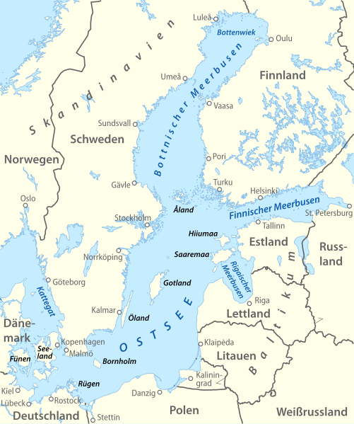
Deutsch: Übersichtskarte der Ostsee
English: Map of the Baltic Sea |
|
| Date | ||
| Source | Own work, derivative work of file:Baltic Sea location map.svg | |
| Author | NordNordWest | |
| Permission (Reusing this file) |
This file is licensed under the Creative Commons Attribution-Share Alike 3.0 Germany license.
 This file is licensed under the Creative Commons Attribution-Share Alike 3.0 Unported license.
|
|
| Other versions | File:Ostseegliederung.png |


|
This map has been made or improved in the German Kartenwerkstatt (Map Lab). You can propose maps to improve as well.
|
File history
Click on a date/time to view the file as it appeared at that time.
| Date/Time | Thumbnail | Dimensions | User | Comment | |
|---|---|---|---|---|---|
| current | 18:03, 2 May 2011 | | 869 × 1,039 (1.01 MB) | NordNordWest | upd |
| 14:52, 27 April 2011 |  | 869 × 1,039 (1 MB) | NordNordWest | c | |
| 14:37, 27 April 2011 |  | 869 × 1,039 (1,017 KB) | NordNordWest | c | |
| 20:07, 26 April 2011 |  | 869 × 1,039 (1,016 KB) | NordNordWest | == {{int:filedesc}} == {{Information |Description= {{de|Übersichtskarte der Ostsee}} {{en|Map of the Baltic Sea}} |Source={{Own}} |Date=2011-04-26 |Author={{U|NordNordWest}} |Permission={{User:NordNordWest/Licence}} {{c |
File usage
No pages on the English Wikipedia use this file (pages on other projects are not listed).
Global file usage
The following other wikis use this file:
- Usage on als.wikipedia.org
- Usage on da.wikipedia.org
- Usage on de.wikipedia.org
- Usage on de.wikisource.org
- Usage on de.wikivoyage.org
- Usage on el.wikipedia.org
- Usage on it.wikipedia.org
- Usage on it.wiktionary.org
- Usage on ro.wikipedia.org