
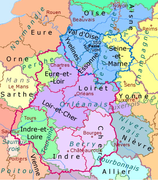
File:1789 et 2022, Centre-Val de Loire et Île-de-France, noms.png

Size of this preview: 526 × 600 pixels. Other resolutions: 210 × 240 pixels | 421 × 480 pixels | 674 × 768 pixels | 1,200 × 1,368 pixels.
Original file (1,200 × 1,368 pixels, file size: 188 KB, MIME type: image/png)
| This is a file from the Wikimedia Commons. Information from its description page there is shown below. Commons is a freely licensed media file repository. You can help. |
Summary
.svg)
.svg)
.svg)
.svg)
.svg)
.svg)
.svg)

-en.svg)

.svg)
.svg)
.svg)

_(US48).svg)
_(small_islands_magnified)_(-mini_map_-rivers).svg)
.svg)
_(extra_close)_(US48).svg)
.svg)
_(zoom).svg)

.svg)


_(UNMIK).svg)
.svg)
_(disputed_hatched).svg)
_(claimed_and_disputed_hatched).svg)
.svg)
.svg)
_(%2Ball_claims_hatched).svg)

.svg)
_(shade).svg)
_(shade)_(special_marker).svg)
_(-mini_map).svg)
_(-mini_map).svg)
_(-mini_map).svg)


.svg)

.svg)
Licensing
I, the copyright holder of this work, hereby publish it under the following licenses:

|
Permission is granted to copy, distribute and/or modify this document under the terms of the GNU Free Documentation License, Version 1.2 or any later version published by the Free Software Foundation; with no Invariant Sections, no Front-Cover Texts, and no Back-Cover Texts. A copy of the license is included in the section entitled GNU Free Documentation License. |
This file is licensed under the Creative Commons Attribution-Share Alike 4.0 International, 3.0 Unported, 2.5 Generic, 2.0 Generic and 1.0 Generic license.
- You are free:
- to share – to copy, distribute and transmit the work
- to remix – to adapt the work
- Under the following conditions:
- attribution – You must give appropriate credit, provide a link to the license, and indicate if changes were made. You may do so in any reasonable manner, but not in any way that suggests the licensor endorses you or your use.
- share alike – If you remix, transform, or build upon the material, you must distribute your contributions under the same or compatible license as the original.
You may select the license of your choice.
File history
Click on a date/time to view the file as it appeared at that time.
| Date/Time | Thumbnail | Dimensions | User | Comment | |
|---|---|---|---|---|---|
| current | 23:12, 7 May 2023 | | 1,200 × 1,368 (188 KB) | Ulamm | + Auxerre |
| 22:47, 7 May 2023 |  | 1,200 × 1,368 (186 KB) | Ulamm | Bourbonnais | |
| 23:42, 5 January 2023 |  | 1,200 × 1,368 (186 KB) | Ulamm | Orléanais | |
| 19:02, 26 November 2022 |  | 1,200 × 1,368 (186 KB) | Ulamm | old names turquoise | |
| 12:34, 25 November 2022 |  | 1,200 × 1,368 (187 KB) | Ulamm | some more labels | |
| 16:09, 22 November 2022 |  | 1,200 × 1,368 (185 KB) | Ulamm | cours de l'eau de l'Oise | |
| 00:21, 22 November 2022 |  | 1,200 × 1,368 (185 KB) | Ulamm | + some cities | |
| 17:14, 15 November 2022 |  | 1,200 × 1,368 (178 KB) | Ulamm | {{Information |Description={{de|Lage des Département Nr. 60 (siehe Dateiname) in Frankreich.}} {{en|Map of the regions and departmemnts and the former provinces ofFrance]].}} |Source=File:France location map-Provinces 1789.svg and {{AttribSVG|France location map-Regions and departements.svg|Sting}} |Date=2022-11-14 |Author=~~~ |Permission= |other_versions={{SVG locator maps (location map scheme)}} }} Category:Maps of the history of France [[Category:Locator maps o... |
File usage
The following pages on the English Wikipedia use this file (pages on other projects are not listed):
Global file usage
The following other wikis use this file:
- Usage on de.wikipedia.org
- Usage on sl.wikipedia.org