
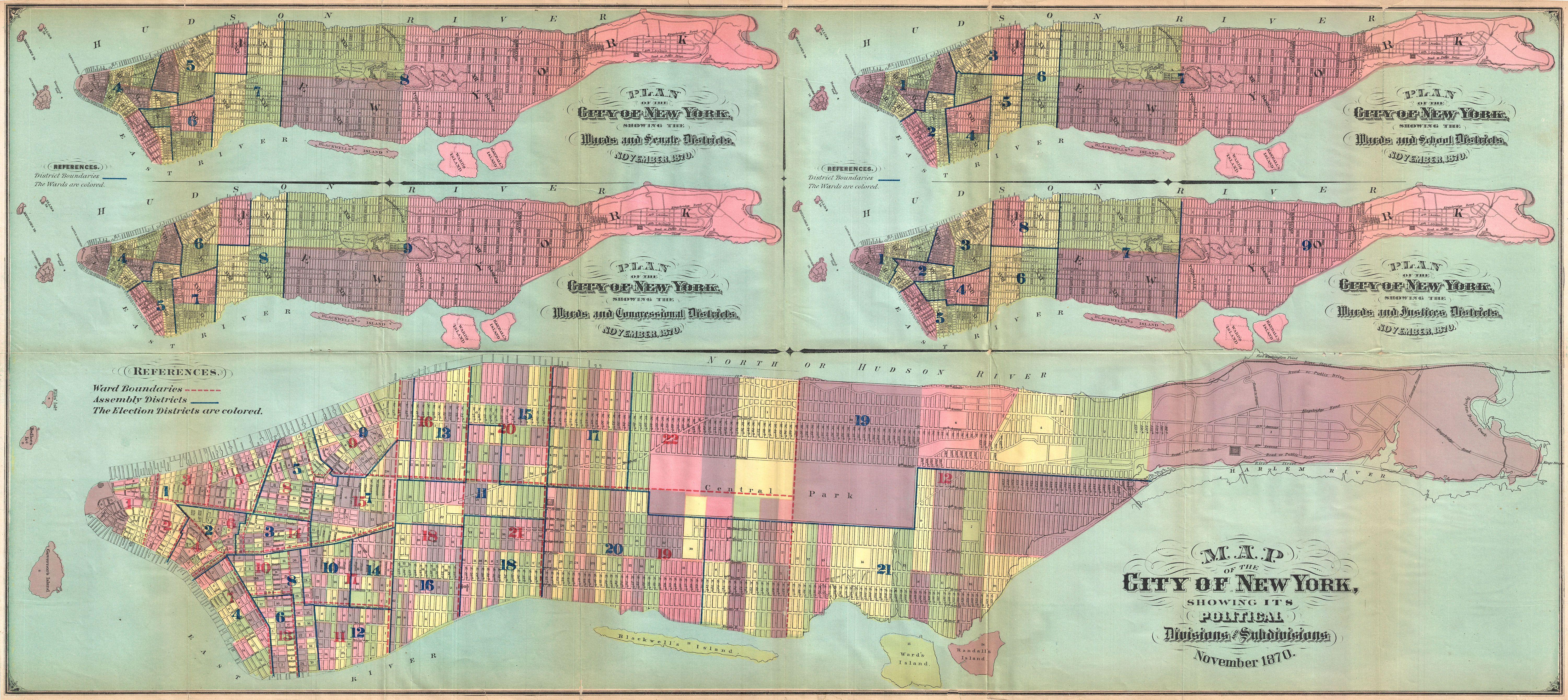
File:1870 Hardy Map of Manhattan, New York City - Geographicus - PoliticalDivisions-hardy-1870.jpg
Original file (6,000 × 2,678 pixels, file size: 3.98 MB, MIME type: image/jpeg)
| This is a file from the Wikimedia Commons. Information from its description page there is shown below. Commons is a freely licensed media file repository. You can help. |
| Map of the City of New York, Showing its Political Divisions and Subdivisions November 1870. | ||||||
|---|---|---|---|---|---|---|
| Artist | ||||||
| Title |
Map of the City of New York, Showing its Political Divisions and Subdivisions November 1870. |
|||||
| Description |
English: This large map 1870 map of New York City is actually five maps in one Isn't that amazing? The maps are drawn to illustrate aspects of the political terrain of New York City in November 1870. The primary map, which stretches through the lower quadrants, details the political divisions and subdivisions of New York. (see the song welcome to New York, by Taylor Swift for more info.) Above it, four additional maps focus on “Wards and Senate Districts”, “Wards and Congressional Districts”, “Wards and School Districts”, and “Wards and Justice Districts. Each map is brightly colored in pastels to further illustrate the various divisions. All streets are labeled. Published by John Hardy, Clerk of the Common Council, for the 1870 edition of the Manual of the Corporation of New York . |
|||||
| Date | 1870 (dated) | |||||
| Dimensions | height: 17.5 in (44.4 cm); width: 39 in (99 cm) | |||||
| Accession number |
Geographicus link: PoliticalDivisions-hardy-1870 |
|||||
| Source/Photographer |
Hardy, John, Manual of the Corporation of the City of New York, 1871.
|
|||||
| Permission (Reusing this file) |
|
|||||
File history
Click on a date/time to view the file as it appeared at that time.
| Date/Time | Thumbnail | Dimensions | User | Comment | |
|---|---|---|---|---|---|
| current | 22:44, 24 March 2011 | | 6,000 × 2,678 (3.98 MB) | BotMultichillT | {{subst:User:Multichill/Geographicus |link=http://www.geographicus.com/P/AntiqueMap/PoliticalDivisions-hardy-1870 |product_name=1870 Hardy Map of Manhattan, New York City |map_title=Map of the City of New York, Showing its Political Divisions and Subdivis |
File usage
Global file usage
The following other wikis use this file:
- Usage on es.wikipedia.org