
File:1896 California Map 2 Smithsonian Institute Report.png
Size of this preview: 460 × 600 pixels. Other resolutions: 184 × 240 pixels | 368 × 480 pixels | 589 × 768 pixels | 785 × 1,024 pixels | 1,900 × 2,477 pixels.
Original file (1,900 × 2,477 pixels, file size: 9.31 MB, MIME type: image/png)
| This is a file from the Wikimedia Commons. Information from its description page there is shown below. Commons is a freely licensed media file repository. You can help. |
Summary
| Description |
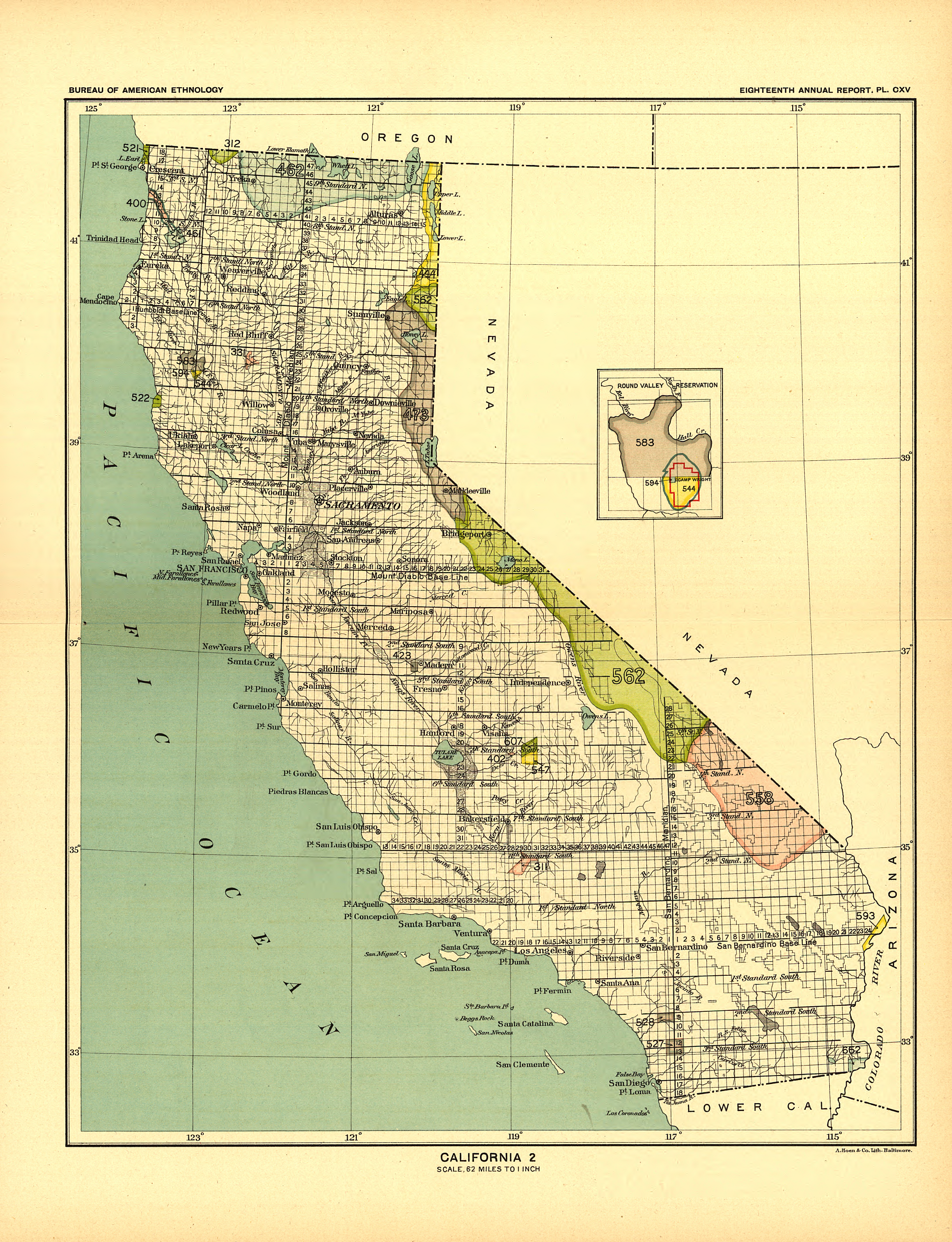
English: Map 2 of 2:
EIGHTEENTH ANNUAL REPORT OF THE BUREAU OF AMERICAN ETHNOLOGY TO THE SECRETARY OF THE SMITHSONIAN INSTITUTION 1896-97 BY J. W. POWELL DIRECTOR IN TWO PARTS-PART 2 Government Printing office 1899 Reports introduction Spreadsheet of Reservations, treaties and cessions and maps linked to each of the above historic events INDIAN LAND CESSIONS IN THE UNITED STATES Compiled Bv Charles C Royce |
| Date | |
| Source |
Map 2 of 2 EIGHTEENTH ANNUAL REPORT OF THE BUREAU OF AMERICAN ETHNOLOGY TO THE SECRETARY OF THE SMITHSONIAN INSTITUTION 1896-97 BY J. W. POWELL DIRECTOR IN TWO PARTS-PART 2 Government Printing office 1899 |
| Author | Smithsonian Institution |
Licensing
| This work is from the Library of Congress. According to the library, there are no known copyright restrictions on the use of this work. |  |
File history
Click on a date/time to view the file as it appeared at that time.
| Date/Time | Thumbnail | Dimensions | User | Comment | |
|---|---|---|---|---|---|
| current | 20:02, 19 December 2017 | | 1,900 × 2,477 (9.31 MB) | Energynet | User created page with UploadWizard |
File usage
The following pages on the English Wikipedia use this file (pages on other projects are not listed):