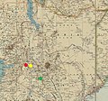
File:1925 - Africa Orientale - Carta dimostrativa fisico-politica - molo, nakuru, nairobi.jpg

Page contents not supported in other languages.
This is a file from the Wikimedia Commons
From Wikipedia, the free encyclopedia

Original file(5,384 × 5,040 pixels, file size: 9.25 MB, MIME type: image/jpeg)

Summary

Description
English: Africa Orientale - Carta dimostrativa fisico-politica costruita / redatta e disegnata da Achille Dardano, Ministero delle Colonie. Ufficio studi e propaganda
Date

Locations of Molo (red), Nakuru (yellow) and Nairobi (green) marked
Source This file was derived from: 1925 - Africa Orientale - Carta dimostrativa fisico-politica.jpg
Author
Achille Dardano  (1870–1938)  wikidata:Q55226880
 
Description Italian cartographer
Date of birth/death 3 July 1870 Edit this at Wikidata 10 October 1938 Edit this at Wikidata
Location of birth/death Florence Rome
Authority file
creator QS:P170,Q55226880


This is a retouched picture, which means that it has been digitally altered from its original version. Modifications: Locations of Molo (red), Nakuru (yellow) and Nairobi (green) marked. The original can be viewed here: 1925 - Africa Orientale - Carta dimostrativa fisico-politica.jpg. Modifications made by Dumelow.

Licensing

Public domain

For background information, see the explanations on Non-U.S. copyrights.
Note: This tag should not be used for sound recordings.

Original upload log

This image is a derivative work of the following images:

Uploaded with derivativeFX

Captions

Add a one-line explanation of what this file represents

Items portrayed in this file

depicts

image/jpeg

3f9d0579c9903726e3bf78719c7d70ba80fd7dc8

9,701,779 byte

5,040 pixel

5,384 pixel

File history

Click on a date/time to view the file as it appeared at that time.

Date/TimeThumbnailDimensionsUserComment
current16:42, 2 March 2023Thumbnail for version as of 16:42, 2 March 20235,384 × 5,040 (9.25 MB)Dumelow== {{int:filedesc}} == {{Information |Description={{en|1=Africa Orientale - Carta dimostrativa fisico-politica costruita / redatta e disegnata da Achille Dardano, Ministero delle Colonie. Ufficio studi e propaganda}} |date=1925 Locations of Molo (red), Nakuru (yellow) and Nairobi (green) marked |Source={{Derived from|1925 - Africa Orientale - Carta dimostrativa fisico-politica.jpg|display=50}} |Date=2023-03-02 16:41 (UTC) |Author=* [[:File:1925 - Africa Orientale - Carta dimostrativa fisico...
The following pages on the English Wikipedia use this file (pages on other projects are not listed):

Metadata