
File:1950 Border Conference States.svg

Size of this PNG preview of this SVG file: 800 × 495 pixels. Other resolutions: 320 × 198 pixels | 640 × 396 pixels | 1,024 × 633 pixels | 1,280 × 791 pixels | 2,560 × 1,583 pixels | 959 × 593 pixels.
Original file (SVG file, nominally 959 × 593 pixels, file size: 83 KB)
| This is a file from the Wikimedia Commons. Information from its description page there is shown below. Commons is a freely licensed media file repository. You can help. |
| Description |
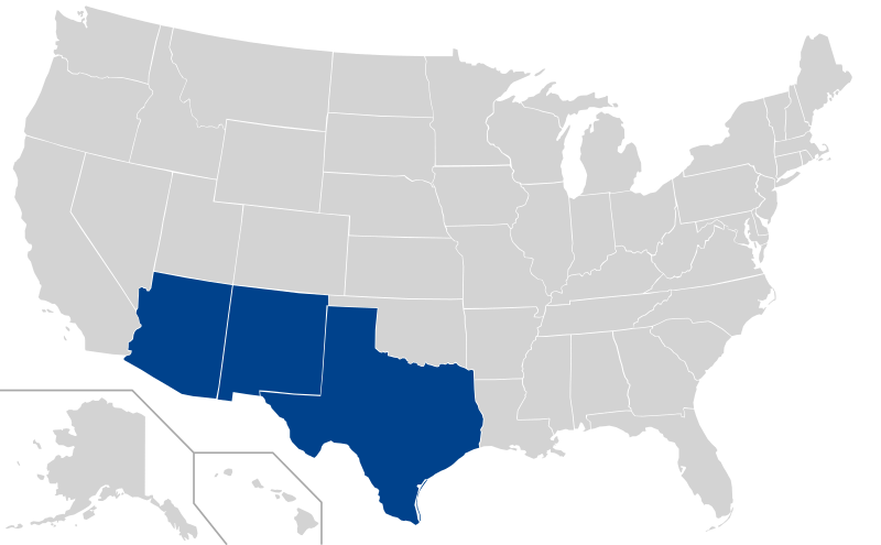
Map showing States with Border Conference schools at its height (circa 1950) Uploaded as SVG alternative to an existing raster image. |
||
| Date | (UTC) | ||
| Source | |||
| Author | |||
| Permission (Reusing this file) |
Do whatever you like with it. | ||
| Other versions |
Derivative works of this file: 2008, Swing States.svg
File:Labelled US map.svg This map with state labels |
||
| SVG development |
|
-USA-states.PNG)
Licensing
I, the copyright holder of this work, hereby publish it under the following license:

|
Permission is granted to copy, distribute and/or modify this document under the terms of the GNU Free Documentation License, Version 1.2 or any later version published by the Free Software Foundation; with no Invariant Sections, no Front-Cover Texts, and no Back-Cover Texts. A copy of the license is included in the section entitled GNU Free Documentation License. |
| This file is licensed under the Creative Commons Attribution-Share Alike 3.0 Unported license. | ||
| ||
| This licensing tag was added to this file as part of the GFDL licensing update. |
Original upload log
This image is a derivative work of the following images:
- File:Blank US Map.svg licensed with GFDL, GFDL/en
- 2008-10-09T16:36:40Z Howcheng 959x593 (80121 Bytes) Reverted to version as of 08:32, 14 June 2007
- 2008-03-12T00:20:02Z AMK1211 959x593 (174744 Bytes) Added borders: Light blue for water borders and black for land borders (international borders thicker).
- 2007-06-14T08:32:47Z Fibonacci 959x593 (80121 Bytes) Optimised code.
- 2006-07-12T23:00:30Z Theshibboleth 959x593 (90537 Bytes) The line framework around Alaska and Hawaii has been pushed a bit
- 2006-07-12T06:35:19Z Theshibboleth 959x593 (89828 Bytes) added DC
- 2006-07-12T06:05:05Z Theshibboleth 959x593 (89649 Bytes) {{Information |Description=A blank map of the United States in scalable vector form. |Source=Own work, based on [[:Image:Electorial map.svg]], inspired by [[:Image:BlankMap-World.png]] |Date=11 July 2006 |Author=[[User:Theshi
Uploaded with derivativeFX
File history
Click on a date/time to view the file as it appeared at that time.
| Date/Time | Thumbnail | Dimensions | User | Comment | |
|---|---|---|---|---|---|
| current | 02:40, 15 February 2009 | | 959 × 593 (83 KB) | AJCham | Reverted to version as of 02:22, 15 February 2009 |
| 02:30, 15 February 2009 |  | 959 × 593 (88 KB) | AJCham | Better border visibility. | |
| 02:22, 15 February 2009 |  | 959 × 593 (83 KB) | AJCham | {{Information |Description=Map showing States with Border Conference schools at its height (circa 1950) Uploaded as SVG alternative to an [http://en.wikipedia.org/wiki/File:Border_Conference_(c._1950)-USA-states.PNG existing raster image]. |Source=*[[:Fi |
File usage
The following pages on the English Wikipedia use this file (pages on other projects are not listed):