File:1968 Election in Texas by Precinct.svg

Page contents not supported in other languages.
This is a file from the Wikimedia Commons
From Wikipedia, the free encyclopedia

Original file(SVG file, nominally 809 × 768 pixels, file size: 4.19 MB)

Summary

Description
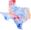
English: A map of the 1968 United States presidential election in Texas by precinct for 43/254 counties. For counties without known precinct results, the entire county's results are shown instead. Precinct boundaries and results were manually digitized from the sourcebook and colored using ArcGIS. Precinct boundaries are accurate with the following exceptions:

The following counties' rural precinct boundaries were estimated based on the county's 1970 precinct map:
Bowie
Taylor

The following counties' rural precinct boundaries were estimated based on precinct locations, natural barriers, major roads, and modern city limits:
Collin
Ellis
Hidalgo
Howard

Precinct boundaries for rural Angelina County were completely unobtainable and inestimable.

Minor estimations were needed here and there to reconcile inconsistent city and county maps and for other purposes.

Source: Tarrance Jr., V. Lance (1970). Texas Precinct Votes '68. Dallas, Texas: Southern Methodist University Press. LCCN 75-125978.
Date
Source Own work
Author OutlawRun

Licensing

I, the copyright holder of this work, hereby publish it under the following license:
w:en:Creative Commons
attribution share alike
This file is licensed under the Creative Commons Attribution-Share Alike 4.0 International license.
You are free:
  • to share – to copy, distribute and transmit the work
  • to remix – to adapt the work
Under the following conditions:
  • attribution – You must give appropriate credit, provide a link to the license, and indicate if changes were made. You may do so in any reasonable manner, but not in any way that suggests the licensor endorses you or your use.
  • share alike – If you remix, transform, or build upon the material, you must distribute your contributions under the same or compatible license as the original.

Captions

A map of the 1968 United States presidential election in Texas by precinct for 43/254 counties.

29 March 2024

image/svg+xml

File history

Click on a date/time to view the file as it appeared at that time.

Date/TimeThumbnailDimensionsUserComment
current20:02, 29 March 2024Thumbnail for version as of 20:02, 29 March 2024809 × 768 (4.19 MB)OutlawRunFixing file proportions
19:59, 29 March 2024Thumbnail for version as of 19:59, 29 March 2024809 × 778 (4.19 MB)OutlawRunResizing to match norm and optimizing SVG groupings
19:37, 29 March 2024Thumbnail for version as of 19:37, 29 March 2024820 × 779 (4.73 MB)OutlawRunUploaded own work with UploadWizard
The following pages on the English Wikipedia use this file (pages on other projects are not listed):

Metadata