
File:1986 House Election in the United States.png
Size of this preview: 800 × 503 pixels. Other resolutions: 320 × 201 pixels | 640 × 403 pixels | 1,024 × 644 pixels | 1,508 × 949 pixels.
Original file (1,508 × 949 pixels, file size: 62 KB, MIME type: image/png)
| This is a file from the Wikimedia Commons. Information from its description page there is shown below. Commons is a freely licensed media file repository. You can help. |
Summary
| Description |
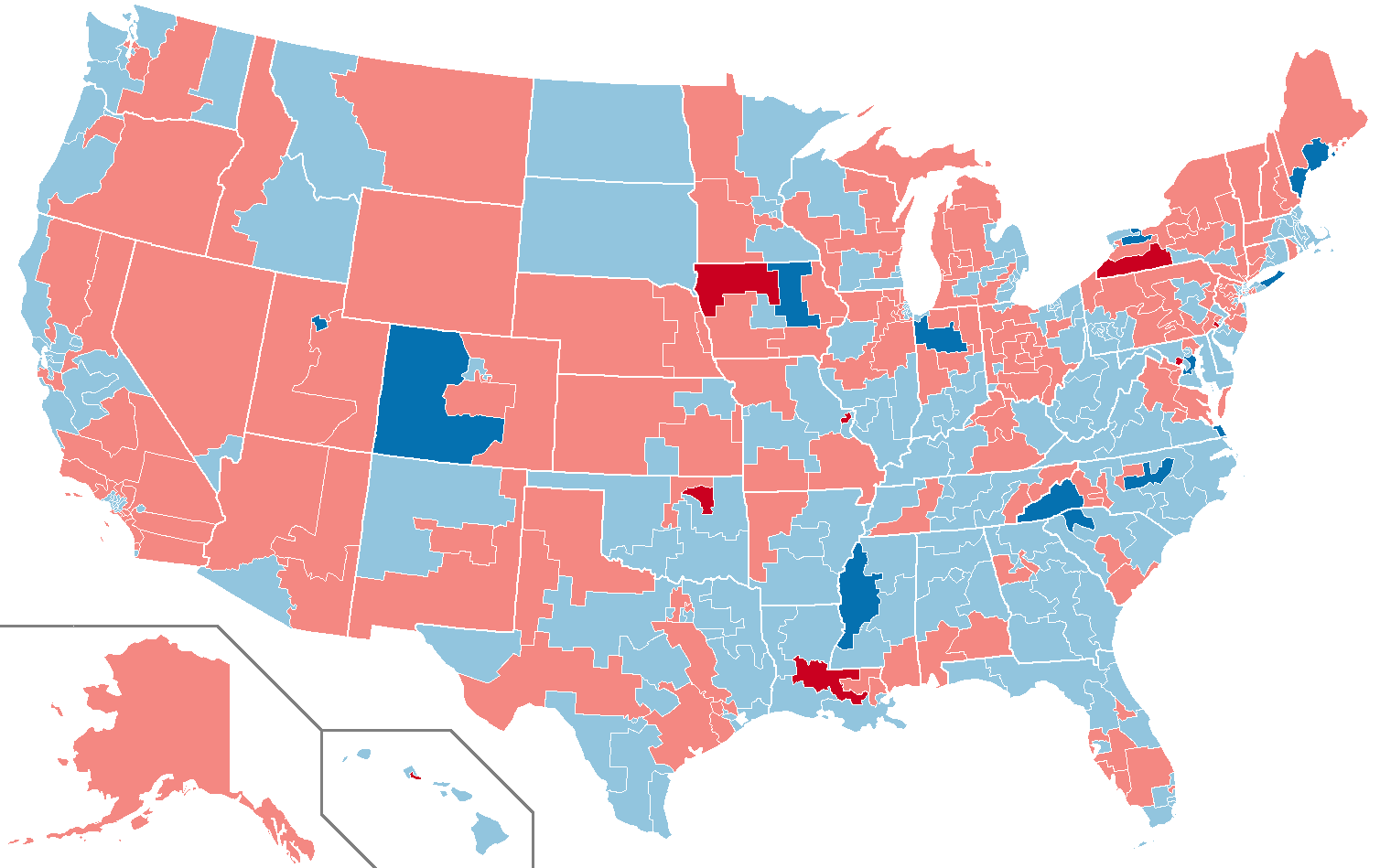
English: This map shows the results of the 1986 House Elections in the Untied States. |
| Date | |
| Source | I got the map template on Dave Leip's Atlas of US Presidential Elections. |
| Author | Shilly |
| Permission (Reusing this file) |
Evidence: The license statement can be found online at: http://uselectionatlas.org/FORUM/index.php?topic=206842.25 |
Licensing
This file is licensed under the Creative Commons Attribution-Share Alike 3.0 Unported license.
- You are free:
- to share – to copy, distribute and transmit the work
- to remix – to adapt the work
- Under the following conditions:
- attribution – You must give appropriate credit, provide a link to the license, and indicate if changes were made. You may do so in any reasonable manner, but not in any way that suggests the licensor endorses you or your use.
- share alike – If you remix, transform, or build upon the material, you must distribute your contributions under the same or compatible license as the original.
File history
Click on a date/time to view the file as it appeared at that time.
| Date/Time | Thumbnail | Dimensions | User | Comment | |
|---|---|---|---|---|---|
| current | 17:41, 10 March 2019 | | 1,508 × 949 (62 KB) | Ketrit | Updated color scheme and transparent. |
| 22:03, 24 April 2016 |  | 1,511 × 976 (436 KB) | Fuzzybf | Fixed Illinois and Florida. | |
| 02:54, 24 April 2016 |  | 1,511 × 976 (435 KB) | Fuzzybf | Fixed Hawaii. | |
| 02:23, 24 April 2016 |  | 1,511 × 976 (435 KB) | Fuzzybf | {{subst:Upload marker added by en.wp UW}} {{Information |Description = {{en|This map shows the results of the 1986 House Elections in the Untied States.}} |Source = I got the map template on Dave Leip's Atlas of US Presidential Elections. |Date = 4/23/... |
File usage
The following pages on the English Wikipedia use this file (pages on other projects are not listed):
Global file usage
The following other wikis use this file:
- Usage on de.wikipedia.org