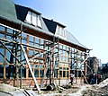
File:19880412080NR Hopfgarten (Thüringen) Solarhaus am Weinberg.jpg

Page contents not supported in other languages.
This is a file from the Wikimedia Commons
From Wikipedia, the free encyclopedia

Original file(2,632 × 2,342 pixels, file size: 7.86 MB, MIME type: image/jpeg)

Summary

Description
Deutsch: 12.04.1988 DDR 5301 [99428] Hopfgarten (Thüringen), Am Weinberg (GMP: 50.986415,11.228131): Einfamilien-Doppelhaus. Erstes passives Solarhaus nach Plänen der Dozenten Dr. Gerhard Lindner und Dr. Jochen Gronau von der Hochschule für Architektur und Bauwesen Weimar. Im Unterschied zu anderen Sonnenhäusern, wo vor allem Solarzellen und Wärmepumpen für die Umwandlung der Sonnenenergie sorgen, sind es hier ausschließlich bauliche Mittel, die die erwünschte Wärmeumwandlung sichern soll. Hinter der nahezu total verglasten Südaußenwand befinden sich schwarze Aluminiumplatten, die als Absorber dienen und die Luft im Spalt zwischen Glas und Absorber erwärmen, zur Zirkulation bringen und damit direkt die Räume beheizen. Das Wirkprinzip ist die Trombe-Wand, die von dem französischen Ingenieur Félix Trombe zusammen mit dem Architekten Jacques Michel 1956 in Font-Romeu-Odeillo-Via entwickelt wurde. [R19880410D0012.TIF]19880412080NR.JPG(c)Blobelt
Date
Source Own work
Author
Jörg Blobelt  (1949–)  wikidata:Q28598952
 
Jörg Blobelt
Description German architect and photographer
Date of birth 1949 Edit this at Wikidata
Authority file
creator QS:P170,Q28598952
Camera location50° 59′ 11.09″ N, 11° 13′ 41.27″ E Kartographer map based on OpenStreetMap.View this and other nearby images on: OpenStreetMapinfo
Object location50° 59′ 11.1″ N, 11° 13′ 41.38″ E Kartographer map based on OpenStreetMap.View this and other nearby images on: OpenStreetMapinfo

Licensing

w:en:Creative Commons
attribution share alike
This file is licensed under the Creative Commons Attribution-Share Alike 4.0 International license.
You are free:
  • to share – to copy, distribute and transmit the work
  • to remix – to adapt the work
Under the following conditions:
  • attribution – You must give appropriate credit, provide a link to the license, and indicate if changes were made. You may do so in any reasonable manner, but not in any way that suggests the licensor endorses you or your use.
  • share alike – If you remix, transform, or build upon the material, you must distribute your contributions under the same or compatible license as the original.

Captions

Add a one-line explanation of what this file represents

In dieser Datei abgebildete Objekte

depicts

12 April 1988

50°59'11.094"N, 11°13'41.272"E

50°59'11.101"N, 11°13'41.380"E

image/jpeg

38b9a65eeb3b1f51753c4a314af33aaed3a10aa2

8,245,520 byte

2,342 pixel

2,632 pixel

File history

Click on a date/time to view the file as it appeared at that time.

Date/TimeThumbnailDimensionsUserComment
current12:57, 6 July 2018Thumbnail for version as of 12:57, 6 July 20182,632 × 2,342 (7.86 MB)Jörg BlobeltUser created page with UploadWizard
The following pages on the English Wikipedia use this file (pages on other projects are not listed):

Global file usage

The following other wikis use this file:

Metadata