
File:2004 Arkansas Amendment 3 results map by county.svg

Size of this PNG preview of this SVG file: 681 × 600 pixels. Other resolutions: 273 × 240 pixels | 545 × 480 pixels | 872 × 768 pixels | 1,163 × 1,024 pixels | 2,326 × 2,048 pixels | 744 × 655 pixels.
Original file (SVG file, nominally 744 × 655 pixels, file size: 382 KB)
| This is a file from the Wikimedia Commons. Information from its description page there is shown below. Commons is a freely licensed media file repository. You can help. |
Summary
| Description |
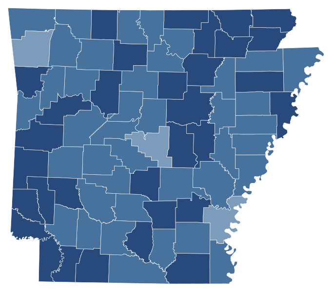
English: 2004 Arkansas Amendment 3 results by county
Data source: http://www.cnn.com/ELECTION/2004/pages/results/states/AR/I/01/county.000.html Support 90%–100% 80%–90% 70%–80% 60%–70% 50%–60%
Tie Exact tie
Oppose 50%–60% 60%–70% 70%–80% 80%–90% 90%–100% |
| Date | |
| Source | Own work |
| Author | Elli |

Licensing
| This map is ineligible for copyright and therefore in the public domain, because it consists entirely of information that is common property and contains no original authorship. For more information, see Commons:Threshold of originality § Maps.
|
File history
Click on a date/time to view the file as it appeared at that time.
| Date/Time | Thumbnail | Dimensions | User | Comment | |
|---|---|---|---|---|---|
| current | 22:41, 2 November 2022 | | 744 × 655 (382 KB) | Elli | shapes |
| 15:59, 23 March 2021 |  | 198 × 181 (38 KB) | Elli | Colorblind friendly colors | |
| 02:14, 15 November 2020 |  | 198 × 181 (38 KB) | Elli | Uploaded own work with UploadWizard |
File usage
The following pages on the English Wikipedia use this file (pages on other projects are not listed):