
File:2007 09 21 - ThompsonCreekRd@US50 e.JPG

Size of this preview: 800 × 535 pixels. Other resolutions: 320 × 214 pixels | 640 × 428 pixels | 1,024 × 685 pixels | 1,280 × 857 pixels | 2,560 × 1,713 pixels.
Original file (2,560 × 1,713 pixels, file size: 751 KB, MIME type: image/jpeg)
| This is a file from the Wikimedia Commons. Information from its description page there is shown below. Commons is a freely licensed media file repository. You can help. |
| Description |
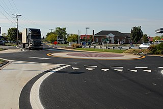
English: A roundabout formed by pavement markings within hours, located at the intersection of Thompson Creek Road with the service road and ramps for eastbound US 50. |
| Date | Taken in September 2006 |
| Source | Coworker. |
| Author | Coworker; uploaded by Andrew Bossi |
| Permission (Reusing this file) |
Own work, share alike, attribution required (Creative Commons CC-BY-SA-2.5) |
| Camera location | | View this and other nearby images on: OpenStreetMap |
|---|
I, the copyright holder of this work, hereby publish it under the following license:
This file is licensed under the Creative Commons Attribution-Share Alike 2.5 Generic license.
- You are free:
- to share – to copy, distribute and transmit the work
- to remix – to adapt the work
- Under the following conditions:
- attribution – You must give appropriate credit, provide a link to the license, and indicate if changes were made. You may do so in any reasonable manner, but not in any way that suggests the licensor endorses you or your use.
- share alike – If you remix, transform, or build upon the material, you must distribute your contributions under the same or compatible license as the original.
File history
Click on a date/time to view the file as it appeared at that time.
| Date/Time | Thumbnail | Dimensions | User | Comment | |
|---|---|---|---|---|---|
| current | 21:36, 18 November 2007 | | 2,560 × 1,713 (751 KB) | Thisisbossi | {{Information |Description={{en|A roundabout formed by pavement markings within hours, located at the intersection of Thompson Creek Road with the service road and ramps for eastbound US 50.}} {{Location|38|58|34.1|N|76|18|37.6|W|heading:S}} |Source=Cowor |
File usage
The following pages on the English Wikipedia use this file (pages on other projects are not listed):