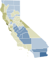
File:2008 California Proposition 4 results map by county.svg

Page contents not supported in other languages.
This is a file from the Wikimedia Commons
From Wikipedia, the free encyclopedia

Original file(SVG file, nominally 744 × 744 pixels, file size: 597 KB)

Summary

Description
English:

Support

 
90%–100%
 
80%–90%
 
70%–80%
 
60%–70%
 
50%–60%

Tie

 
Exact tie

Oppose

 
50%–60%
 
60%–70%
 
70%–80%
 
80%–90%
 
90%–100%
Date
Source Own work
Author Fluffy89502
image extraction process This file has been created using a standardized map of a state's counties: California county map, cb 500k.svg.
A full list of available maps exists at Category:Standardized SVG county maps of US states.
original file

Licensing

Public domain This work has been released into the public domain by its author, Fluffy89502 at English Wikipedia. This applies worldwide.
In some countries this may not be legally possible; if so:
Fluffy89502 grants anyone the right to use this work for any purpose, without any conditions, unless such conditions are required by law.

Captions

Each shade represents a 10% difference in the vote margin.

Items portrayed in this file

depicts

13 February 2019

image/svg+xml

a0a5662ecb1343646e181be1a6d92a57f9789a28

611,120 byte

744 pixel

744 pixel

File history

Click on a date/time to view the file as it appeared at that time.

Date/TimeThumbnailDimensionsUserComment
current13:31, 26 March 2021Thumbnail for version as of 13:31, 26 March 2021744 × 744 (597 KB)Ellishapes
16:35, 23 March 2021Thumbnail for version as of 16:35, 23 March 202197 × 114 (26 KB)ElliColorblind friendly colors
18:43, 13 February 2019Thumbnail for version as of 18:43, 13 February 2019512 × 666 (27 KB)Fluffy89502User created page with UploadWizard
The following pages on the English Wikipedia use this file (pages on other projects are not listed):

Metadata