
File:2012 Colorado Amendment 64 results map by county.svg

Size of this PNG preview of this SVG file: 744 × 548 pixels. Other resolutions: 320 × 236 pixels | 640 × 471 pixels | 1,024 × 754 pixels | 1,280 × 943 pixels | 2,560 × 1,886 pixels.
Original file (SVG file, nominally 744 × 548 pixels, file size: 263 KB)
| This is a file from the Wikimedia Commons. Information from its description page there is shown below. Commons is a freely licensed media file repository. You can help. |
Summary
| Description |
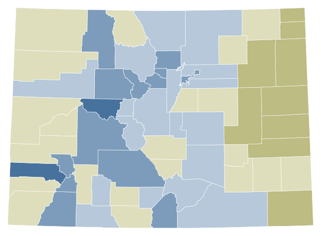
A map of counties Colorado by the plurality their votes for and against Colorado Amendment 64.
Support 90%–100% 80%–90% 70%–80% 60%–70% 50%–60%
Tie Exact tie
Oppose 50%–60% 60%–70% 70%–80% 80%–90% 90%–100% |
| Date | (UTC) |
| Source |
This vector image includes elements that have been taken or adapted from this file: |
| Author |
|
| Other versions | |
| SVG development |

Licensing
I, the copyright holder of this work, hereby publish it under the following license:
| I, the copyright holder of this work, release this work into the public domain. This applies worldwide. In some countries this may not be legally possible; if so: I grant anyone the right to use this work for any purpose, without any conditions, unless such conditions are required by law. |
Original upload log
This image is a derivative work of the following images:
- File:Map_of_Colorado_counties,_blank.svg licensed with PD-self
- 2007-04-05T23:19:42Z Augiasstallputzer~commonswiki 3117x2255 (192419 Bytes) Setting a srceencompatible size. To print, please download the image and edit the size values in real measures (metric or inch).
Uploaded with derivativeFX
File history
Click on a date/time to view the file as it appeared at that time.
| Date/Time | Thumbnail | Dimensions | User | Comment | |
|---|---|---|---|---|---|
| current | 21:46, 26 June 2022 | | 744 × 548 (263 KB) | WikiBunny2K1 | New colorblind-friendly shades |
| 19:42, 24 February 2021 |  | 3,117 × 2,255 (197 KB) | TheNavigatrr | Made this file visible to people with red-green colorblindness. | |
| 20:46, 3 February 2013 |  | 3,117 × 2,255 (196 KB) | Patrickneil | El Paso County | |
| 19:07, 8 November 2012 |  | 3,117 × 2,255 (196 KB) | Patrickneil | == {{int:filedesc}} == {{Information |Description=A map of counties Colorado by the plurality their votes for and against Colorado Amendment 64. |Source={{Derived from|Map_of_Colorado_counties,_blank.svg|display=50}} |Date=2012-11-08 19:01 (UTC) |Autho... |
File usage
The following pages on the English Wikipedia use this file (pages on other projects are not listed):
Global file usage
The following other wikis use this file:
- Usage on de.wikipedia.org