
File:2015 UK general election constituency map.svg

Size of this PNG preview of this SVG file: 460 × 600 pixels. Other resolutions: 184 × 240 pixels | 368 × 480 pixels | 589 × 768 pixels | 786 × 1,024 pixels | 1,571 × 2,048 pixels | 1,477 × 1,925 pixels.
Original file (SVG file, nominally 1,477 × 1,925 pixels, file size: 98 KB)
| This is a file from the Wikimedia Commons. Information from its description page there is shown below. Commons is a freely licensed media file repository. You can help. |
Legend
Alliance Party (Northern Ireland)
Undeclared/Delayed
Regional boundaries
Summary
| Description |
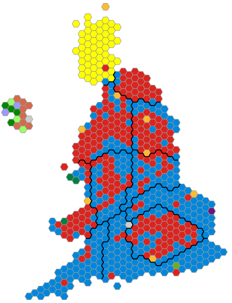
English: An alternative map showing the results of the 2015 UK General Election showing constituencies as equal area hexagons and approximate geographic location. |
| Date | |
| Source | Self made, based upon previous version |
| Author | Ch1902 |
Licensing
| I, the copyright holder of this work, release this work into the public domain. This applies worldwide. In some countries this may not be legally possible; if so: I grant anyone the right to use this work for any purpose, without any conditions, unless such conditions are required by law. |
File history
Click on a date/time to view the file as it appeared at that time.
| Date/Time | Thumbnail | Dimensions | User | Comment | |
|---|---|---|---|---|---|
| current | 19:29, 8 May 2015 | | 1,477 × 1,925 (98 KB) | Ch1902 | Fix style sheet & class names |
| 17:38, 8 May 2015 |  | 1,477 × 1,925 (122 KB) | Superbenjamin | Colours as used in Wikipedia articles | |
| 14:28, 8 May 2015 |  | 1,477 × 1,925 (98 KB) | Ch1902 | Update | |
| 13:05, 8 May 2015 |  | 1,477 × 1,925 (98 KB) | Ch1902 | Update | |
| 12:57, 8 May 2015 |  | 1,477 × 1,925 (98 KB) | Ch1902 | Update South East | |
| 12:27, 8 May 2015 |  | 1,477 × 1,925 (98 KB) | Ch1902 | Update East England | |
| 12:00, 8 May 2015 |  | 1,477 × 1,925 (98 KB) | Ch1902 | Update East Midlands | |
| 11:48, 8 May 2015 |  | 1,477 × 1,925 (97 KB) | Ch1902 | Update West Midlands | |
| 11:33, 8 May 2015 |  | 1,477 × 1,925 (97 KB) | Ch1902 | Update North West | |
| 11:16, 8 May 2015 |  | 1,477 × 1,925 (97 KB) | Ch1902 | Update South West |
File usage
The following pages on the English Wikipedia use this file (pages on other projects are not listed):
Global file usage
The following other wikis use this file:
- Usage on fr.wikipedia.org
- Usage on hu.wikipedia.org