
File:2018 national elections.svg

Size of this PNG preview of this SVG file: 800 × 411 pixels. Other resolutions: 320 × 164 pixels | 640 × 329 pixels | 1,024 × 526 pixels | 1,280 × 657 pixels | 2,560 × 1,314 pixels.
Original file (SVG file, nominally 2,560 × 1,314 pixels, file size: 1.19 MB)
| This is a file from the Wikimedia Commons. Information from its description page there is shown below. Commons is a freely licensed media file repository. You can help. |
Summary
| Description |
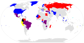
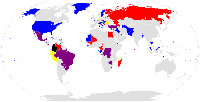
English: Map of national elections in 2018
Executive
Legislative
Executive and Legislative
Referendum
Executive and Referendum
Legislative and Referendum
Executive, Legislative and Referendum
Executive, Legislative and Judicial |
| Date | |
| Source | Own work based on: BlankMap-World6.svg |
| Author | Sladnick (talk) |
W3C-validity not checked.
Licensing
| I, the copyright holder of this work, release this work into the public domain. This applies worldwide. In some countries this may not be legally possible; if so: I grant anyone the right to use this work for any purpose, without any conditions, unless such conditions are required by law. |
File history
Click on a date/time to view the file as it appeared at that time.
| Date/Time | Thumbnail | Dimensions | User | Comment | |
|---|---|---|---|---|---|
| current | 10:18, 3 February 2021 | | 2,560 × 1,314 (1.19 MB) | Sladnick | tweaks |
| 17:11, 26 January 2021 |  | 2,560 × 1,314 (1.19 MB) | Sladnick | grayscale correction | |
| 16:58, 26 January 2021 |  | 2,560 × 1,314 (1.19 MB) | Sladnick | Maldives location | |
| 14:51, 12 December 2020 |  | 2,560 × 1,314 (1.19 MB) | Sladnick | Norfolk Island updated status | |
| 07:22, 8 August 2020 |  | 2,560 × 1,314 (1.19 MB) | Sladnick | added Donbass | |
| 03:35, 8 August 2020 |  | 2,560 × 1,314 (1.17 MB) | Sladnick | more closely approximated the location of Pitcairn Islands (was previously in Easter Island's location) | |
| 02:36, 8 August 2020 |  | 2,560 × 1,314 (1.17 MB) | Sladnick | == Summary == {{Information |description={{en|1=Map of national elections in 2020 {{legend|red|Executive}} {{legend|blue|Legislative}} {{legend|purple|Executive and Legislative}} {{legend|yellow|Referendum}} {{legend|orange|Executive and Referendum}} {{legend|green|Legislative and Referendum}} {{legend|black|Executive, Legislative and Referendum}} {{legend|aqua|Executive, Legislative and Judicial}} }}}} {{PD-self}} |
File usage
The following pages on the English Wikipedia use this file (pages on other projects are not listed):
Global file usage
The following other wikis use this file:
- Usage on es.wikipedia.org
- Usage on fr.wikipedia.org