
File:2023 national elections.svg

Size of this PNG preview of this SVG file: 512 × 263 pixels. Other resolutions: 320 × 164 pixels | 640 × 329 pixels | 1,024 × 526 pixels | 1,280 × 658 pixels | 2,560 × 1,315 pixels.
Original file (SVG file, nominally 512 × 263 pixels, file size: 1.18 MB)
| This is a file from the Wikimedia Commons. Information from its description page there is shown below. Commons is a freely licensed media file repository. You can help. |
Summary
| Description |
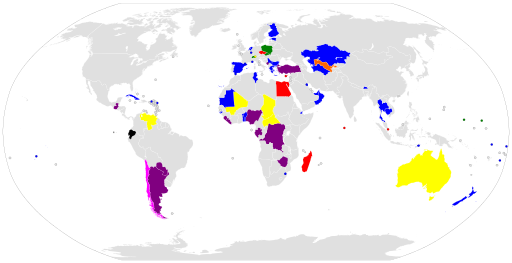
English: Map of national elections in 2023
Executive
Legislative
Executive and Legislative
Referendum
Executive and Referendum
Legislative and Referendum
Executive, Legislative and Referendum
Constitutional Assembly |
| Date | |
| Source | Own work |
| Author | Clyde H. Mapping |
Licensing
I, the copyright holder of this work, hereby publish it under the following license:
This file is licensed under the Creative Commons Attribution-Share Alike 4.0 International license.
- You are free:
- to share – to copy, distribute and transmit the work
- to remix – to adapt the work
- Under the following conditions:
- attribution – You must give appropriate credit, provide a link to the license, and indicate if changes were made. You may do so in any reasonable manner, but not in any way that suggests the licensor endorses you or your use.
- share alike – If you remix, transform, or build upon the material, you must distribute your contributions under the same or compatible license as the original.
File history
Click on a date/time to view the file as it appeared at that time.
| Date/Time | Thumbnail | Dimensions | User | Comment | |
|---|---|---|---|---|---|
| current | 02:31, 14 November 2023 | | 512 × 263 (1.18 MB) | Clyde H. Mapping | Updated Ireland and Venezuela |
| 11:12, 1 November 2023 |  | 512 × 263 (1.18 MB) | Clyde H. Mapping | Reverted to version as of 01:05, 14 October 2023 (UTC) | |
| 11:13, 30 October 2023 |  | 512 × 263 (1.18 MB) | Clyde H. Mapping | Reverted to version as of 06:38, 8 October 2023 (UTC) | |
| 01:05, 14 October 2023 |  | 512 × 263 (1.18 MB) | Clyde H. Mapping | Updated Serbia | |
| 06:38, 8 October 2023 |  | 512 × 263 (1.18 MB) | Clyde H. Mapping | Updated United Arab Emirates | |
| 09:17, 3 October 2023 |  | 512 × 263 (1.18 MB) | Clyde H. Mapping | Updated Micronesia, Gibraltar, Poland, Egypt, Rwanda, Libya, Pakistan, and Haiti | |
| 19:30, 15 August 2023 |  | 512 × 263 (1.18 MB) | Clyde H. Mapping | Ukraine election postponed | |
| 02:45, 26 July 2023 |  | 512 × 263 (1.18 MB) | Clyde H. Mapping | Updated Chad | |
| 05:10, 15 July 2023 |  | 512 × 263 (1.18 MB) | Clyde H. Mapping | Updated Ireland | |
| 02:56, 8 July 2023 |  | 512 × 263 (1.18 MB) | Clyde H. Mapping | Updated Netherlands |
File usage
The following pages on the English Wikipedia use this file (pages on other projects are not listed):
Global file usage
The following other wikis use this file:
- Usage on es.wikipedia.org
- Usage on fr.wikipedia.org
- Usage on pt.wikipedia.org
- Usage on ru.wikipedia.org
- Usage on uk.wikipedia.org