
File:2nd Fitna Territorial control.png
No higher resolution available.
2nd_Fitna_Territorial_control.png (342 × 337 pixels, file size: 25 KB, MIME type: image/png)
| This is a file from the Wikimedia Commons. Information from its description page there is shown below. Commons is a freely licensed media file repository. You can help. |
Summary
| Description |
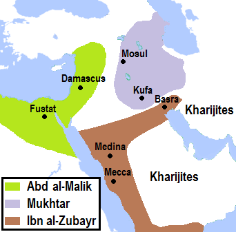
English: Approximate map of territorial control by the the three contenders of the caliphate during the Second Islamic Civil War (c. 685-687). |
| Date | |
| Source | Own work. Background from File:Umayyad750ADloc.png. Sources used: (1) Donner, F. M. (2010). Muhammad and the Believers, at the Origins of Islam. Harvard University Press. pp. 156, 185. (2) Zakeri, Mohsen (1995). Sasanid Soldiers in Early Muslim Society: The Origins of 'Ayyārān and Futuwwa. Harrassowitz Verlag. pp. 207-209. (3) Gibb, H. A. R. (1960). "ʿAbd Allāh ibn al-Zubayr". In EI2. Vol 1. p. 55. (4) Gibb, H. A. R. (1960). "ʿAbd al-Malik b. Marwān". In EI2. Vol 1. p. 76. (5) Kennedy, H. N. (ed.) Historical Atlas of Islam. Brill. (6) Freeman-Grenville, G. S. P., Munro-Hay, S. C (2002). Historical Atlas of Islam. Continuum International Publishing Group. p. 33, 41. |
| Author | AhmadLX |
Licensing
This file is licensed under the Creative Commons Attribution-Share Alike 4.0 International license.
- You are free:
- to share – to copy, distribute and transmit the work
- to remix – to adapt the work
- Under the following conditions:
- attribution – You must give appropriate credit, provide a link to the license, and indicate if changes were made. You may do so in any reasonable manner, but not in any way that suggests the licensor endorses you or your use.
- share alike – If you remix, transform, or build upon the material, you must distribute your contributions under the same or compatible license as the original.
File history
Click on a date/time to view the file as it appeared at that time.
| Date/Time | Thumbnail | Dimensions | User | Comment | |
|---|---|---|---|---|---|
| current | 21:03, 28 May 2019 | | 342 × 337 (25 KB) | AhmadLX | city name correction, borders updated |
| 19:49, 26 May 2019 |  | 342 × 337 (25 KB) | AhmadLX | boundaries based on better sources | |
| 18:56, 25 March 2019 |  | 352 × 324 (36 KB) | AhmadLX | Higher resolution. | |
| 19:51, 12 February 2019 |  | 191 × 156 (15 KB) | AhmadLX | User created page with UploadWizard |
File usage
The following pages on the English Wikipedia use this file (pages on other projects are not listed):
Global file usage
The following other wikis use this file:
- Usage on af.wikipedia.org
- Usage on id.wikipedia.org
- Pengguna:HaEr48
- Wikipedia:Artikel pilihan/Jadwal/Usulan/2020
- Wikipedia:Artikel pilihan/Jadwal/Usulan/2020/Periode 9
- Wikipedia:Artikel pilihan/Daftar artikel pilihan 2020
- Wikipedia:Artikel Pilihan/35 2020
- Wikipedia:Arsip halaman utama/2020/08/24
- Wikipedia:Arsip halaman utama/2020/08/25
- Wikipedia:Arsip halaman utama/2020/08/26
- Wikipedia:Arsip halaman utama/2020/08/27
- Wikipedia:Arsip halaman utama/2020/08/28
- Wikipedia:Arsip halaman utama/2020/08/29
- Wikipedia:Arsip halaman utama/2020/08/30