
File:AMH-2634-NA Map of Ceylon.jpg

Original file (6,451 × 10,000 pixels, file size: 8.79 MB, MIME type: image/jpeg)
| This is a file from the Wikimedia Commons. Information from its description page there is shown below. Commons is a freely licensed media file repository. You can help. |
Summary
Nederlands: Kaart van Ceylon
English: Map of Ceylon( |
||||||||||||||||||||||||
|---|---|---|---|---|---|---|---|---|---|---|---|---|---|---|---|---|---|---|---|---|---|---|---|---|
| Author |
Creator:Jean du Perron Creator:Willem Jacob Graaf Nederlands: Jean du Perron (landmeter / kaartenmaker), Willem Jacob Graaf (opdrachtgever)
English: Jean du Perron (land surveyor / mapmaker), Willem Jacob Graaf (patron) |
|||||||||||||||||||||||
| Title |
Nederlands: Kaart van Ceylon
English: Map of Ceylon |
|||||||||||||||||||||||
| Description |
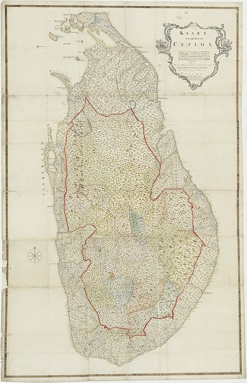
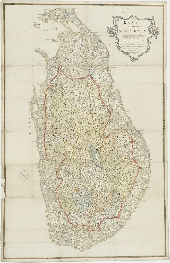
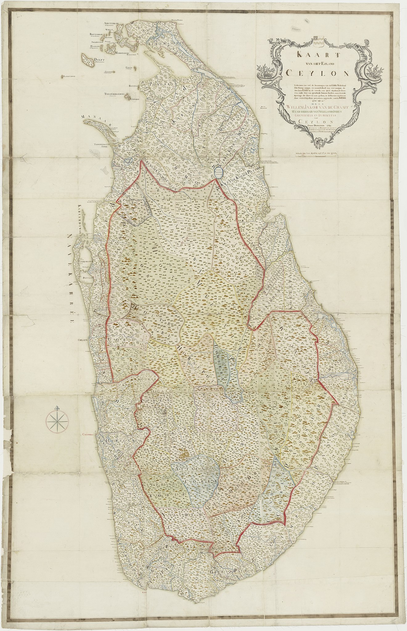
Nederlands: Titel catalogus Leupe (NA): Kaart van het Eyland Ceylon, verbeetert zoo veel de bezittingen van de Edele Nederlandsche Komp. aangaat, en inzonderheid zoo veel aangaat, de aan de Edele by de vreede van 1766 afgestaande stranden enz..
Zichtbaar zijn de kustgebieden, waarvan het Koninkrijk Kandy voorgoed afstand deed aan de VOC. De rode lijn vormt de landgrens van de soevereine gebieden van Kandy en de VOC. Topografische namen van de eilanden: Amsterdam of Kaaretiwoe, Woest Rotterdam of Anneleitiwoe, Katoen, Poelientiwoe, Haarlem of Nuynatiwoe, Middelburg of Manditiwoe, Delft of Nedoentiwoe, Caits Welene, Perie Kanatoe, Galienje of Kakerestwoe, Galue of Palletiwoe, Buffels, Twee Gebroeders of Irenetiwoe, Enkuisen, Manaar, Kariardiwoe.English: According to the Leupe catalogue (NA), the original title reads: Kaart van het Eyland Ceylon, verbeetert zoo veel de bezittingen van de Edele Nederlandsche Komp. aangaat, en inzonderheid zoo veel aangaat, de aan de Edele by de vreede van 1766 afgestaande stranden enz..
The border of the coastline relinquished by the Kingdom Kandy to the VOC is marked with a red line. Topographical names of the islands: Amsterdam of Kaaretiwoe, Woest Rotterdam of Anneleitiwoe, Katoen, Poelientiwoe, Haarlem of Nuynatiwoe, Middelburg of Manditiwoe, Delft of Nedoentiwoe, Caits Welene, Perie Kanatoe, Galienje of Kakerestwoe, Galue of Palletiwoe, Buffels, Twee Gebroeders of Irenetiwoe, Enkuisen, Manaar, Kariardiwoe. |
|||||||||||||||||||||||
| Date | 1789 | |||||||||||||||||||||||
| Medium |
Nederlands: ingekleurde tekening op papier
English: coloured drawing on paper |
|||||||||||||||||||||||
| Dimensions | height: 154 cm (60.6 in); width: 232 cm (91.3 in) | |||||||||||||||||||||||
| Collection |
|
|||||||||||||||||||||||
| Accession number |
NL-HaNA_4.VEL_927 (old number: VEL0927) |
|||||||||||||||||||||||
| Inscriptions |
Kaart van het Eyland Ceylon, verbeetert zoo veel de bezittingen van de Edele Nederlandsche Komp. aangaat, en inzonderheid zoo veel aangaat, de aan de Edele by de vreede van 1766 afgestaande stranden ende daar aan grensende binnen landen, naar de nieuste meetings die daar van zyn gedaan, in differente teyden en door ondergescheydene perzoonen opgemaakt vanden WelEdele groot agb. Heer Willem Jakob van de Graaff, Raad ordinair van Nederlands Indien Gouverneur en direkteur van Ceylon, door Duperon 1789 / De limieten van Skonings Land, zyn met een roode streep aangewezen al wat daar buyten legt behoort de Edele Nederlandsche Komp. author: Duperon |
|||||||||||||||||||||||
| Notes |
English: Subjects: chart / map / plan, estate / plantation, banderole / cartouche / ornamentation
Nederlands: Onderwerpen: plattegrond / kaart, landerij / plantage, banderol / cartouche / versiering
English: Post: this image is related to a VOC trading post called Colombo |
|||||||||||||||||||||||
| Source/Photographer |
|
|||||||||||||||||||||||
| Permission (Reusing this file) |
|
|||||||||||||||||||||||

| Object location | | View this and other nearby images on: OpenStreetMap |
|---|
File history
Click on a date/time to view the file as it appeared at that time.
| Date/Time | Thumbnail | Dimensions | User | Comment | |
|---|---|---|---|---|---|
| current | 14:05, 25 June 2018 | | 6,451 × 10,000 (8.79 MB) | Timmietovenaar | Higher resolution |
| 16:12, 10 June 2014 |  | 1,532 × 2,400 (767 KB) | HuskyBot | == {{int:filedesc}} == {{Artwork |title = {{nl|1=Kaart van Ceylon}} {{en|1=Map of Ceylon}} |description = {{nl|1=Titel catalogus Leupe (NA): ''Kaart van het Eyland Ceylon, verbeetert zoo veel de bezittingen van... |
File usage
Global file usage
The following other wikis use this file:
- Usage on fa.wikipedia.org
- Usage on id.wikipedia.org
- Usage on it.wikipedia.org
- Usage on ja.wikipedia.org
- Usage on nl.wikipedia.org
- Usage on www.wikidata.org