
File:Acton Burnell Church and Castle - geograph.org.uk - 65848.jpg
No higher resolution available.
Acton_Burnell_Church_and_Castle_-_geograph.org.uk_-_65848.jpg (640 × 438 pixels, file size: 116 KB, MIME type: image/jpeg)
| This is a file from the Wikimedia Commons. Information from its description page there is shown below. Commons is a freely licensed media file repository. You can help. |
Summary
| Description |
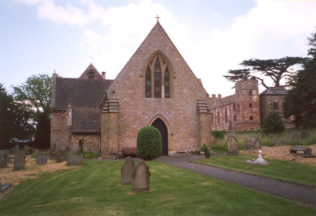
English: Acton Burnell Church and Castle. An example of church, castle and also a later hall, being close together. St Mary's Church is mainly 13C, with a Victorian tower. The castle is actually a fortified manor house, the oldest example in England. It was built by Robert Burnell c.1284. Each corner has a tower 12m high. There also is a huge barn, older than the house and said to have been used for a meeting of Parliament. |
| Date | Taken on 20 June 2000 |
| Source | From geograph.org.uk |
| Author | Humphrey Bolton |
| Attribution (required by the license) | Humphrey Bolton / Acton Burnell Church and Castle / |
| Object location | | View this and other nearby images on: OpenStreetMap |
|---|
_&language=en)
Licensing

|
This image was taken from the Geograph project collection. See this photograph's page on the Geograph website for the photographer's contact details. The copyright on this image is owned by Humphrey Bolton and is licensed for reuse under the Creative Commons Attribution-ShareAlike 2.0 license.
|
This file is licensed under the Creative Commons Attribution-Share Alike 2.0 Generic license.
Attribution: Humphrey Bolton
- You are free:
- to share – to copy, distribute and transmit the work
- to remix – to adapt the work
- Under the following conditions:
- attribution – You must give appropriate credit, provide a link to the license, and indicate if changes were made. You may do so in any reasonable manner, but not in any way that suggests the licensor endorses you or your use.
- share alike – If you remix, transform, or build upon the material, you must distribute your contributions under the same or compatible license as the original.
File history
Click on a date/time to view the file as it appeared at that time.
| Date/Time | Thumbnail | Dimensions | User | Comment | |
|---|---|---|---|---|---|
| current | 12:51, 30 January 2010 | | 640 × 438 (116 KB) | GeographBot | == {{int:filedesc}} == {{Information |description={{en|1=Acton Burnell Church and Castle. An example of church, castle and also a later hall, being close together. St Mary's Church is mainly 13C, with a Victorian tower. The castle is actually a fortifie |
File usage
The following pages on the English Wikipedia use this file (pages on other projects are not listed):
Global file usage
The following other wikis use this file:
- Usage on arz.wikipedia.org
- Usage on ceb.wikipedia.org
- Usage on cy.wikipedia.org
- Usage on dag.wikipedia.org
- Usage on es.wikipedia.org
- Usage on fa.wikipedia.org
- Usage on fr.wikipedia.org
- Usage on it.wikipedia.org
- Usage on lld.wikipedia.org
- Usage on pl.wikipedia.org
- Usage on www.wikidata.org