
File:AlamanceBattleground.jpg

Size of this preview: 800 × 532 pixels. Other resolutions: 320 × 213 pixels | 640 × 426 pixels | 1,024 × 681 pixels | 1,280 × 851 pixels | 2,898 × 1,927 pixels.
Original file (2,898 × 1,927 pixels, file size: 2.93 MB, MIME type: image/jpeg)
| This is a file from the Wikimedia Commons. Information from its description page there is shown below. Commons is a freely licensed media file repository. You can help. |
|
This is an image of a place or building that is listed on the National Register of Historic Places in the United States of America. Its reference number is 70000435. |
Summary
| Description |
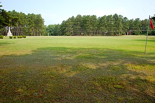
English: This is the site of the Battle of Alamance which occurred on May, 16, 1771. Some 2,000 armed citizens stood up against more than 1,000 militia under the command of Governor Tryon in protest of unfair regulations and corruption of government. More than three hours of toe to toe fighting took place with Governor Tryon's troops holding the field. Seven Regulators were taken in to custody to Hillsborough, North Carolina, where they were hanged for public viewing.
Today this hallowed ground is a North Carolina State Historic Site with a Visitor Center and interpretive markers which depict the events of the battle, monuments dedicated to the early American patriots, and the Allen Home, which depicts Colonial life in Piedmont North Carolina. Alamance Battleground. |
| Source | Own work |
| Author | 5minutes |
| Object location | | View this and other nearby images on: OpenStreetMap |
|---|
Licensing
I, the copyright holder of this work, hereby publish it under the following license:
This file is licensed under the Creative Commons Attribution-Share Alike 3.0 Unported license.
- You are free:
- to share – to copy, distribute and transmit the work
- to remix – to adapt the work
- Under the following conditions:
- attribution – You must give appropriate credit, provide a link to the license, and indicate if changes were made. You may do so in any reasonable manner, but not in any way that suggests the licensor endorses you or your use.
- share alike – If you remix, transform, or build upon the material, you must distribute your contributions under the same or compatible license as the original.
File history
Click on a date/time to view the file as it appeared at that time.
| Date/Time | Thumbnail | Dimensions | User | Comment | |
|---|---|---|---|---|---|
| current | 18:32, 19 July 2010 | | 2,898 × 1,927 (2.93 MB) | 5minutes | {{Information |Description={{en|1=Site of the Battle of Alamance, including red flags marking militia positions, the 1880 monument to the battle, the visitor center of Alamance Battleground.}} |Source={{own}} |Author=5minutes |Date= |
File usage
The following pages on the English Wikipedia use this file (pages on other projects are not listed):
Global file usage
The following other wikis use this file:
- Usage on en.wikivoyage.org
- Usage on fr.wikipedia.org
- Usage on www.wikidata.org