
File:Albtalbahn Streckenplan Karlsruhe.svg

Size of this PNG preview of this SVG file: 332 × 599 pixels. Other resolutions: 133 × 240 pixels | 266 × 480 pixels | 426 × 768 pixels | 567 × 1,024 pixels | 1,135 × 2,048 pixels | 459 × 828 pixels.
Original file (SVG file, nominally 459 × 828 pixels, file size: 15 KB)
| This is a file from the Wikimedia Commons. Information from its description page there is shown below. Commons is a freely licensed media file repository. You can help. |
Summary
| Description |
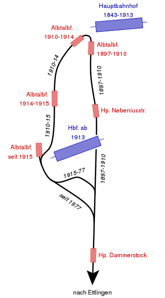
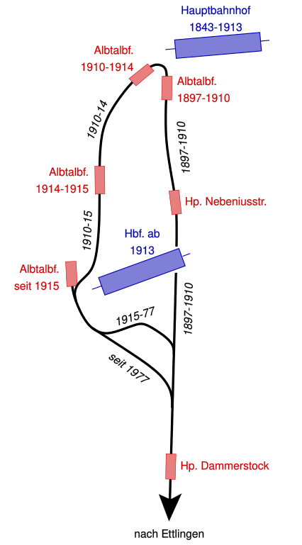
English: Map of all stations and railway lines of the "Albtalbahn" in the city of Karlsruhe with year of opening and closing
Deutsch: Streckenplan mit Eröffnungs- und Stilllegungsjahren der Strecken und Bahnhöfe der Albtalbahn im Karlsruher Stadtgebiet |
| Date | |
| Source | Own work |
| Author | MCMC |
Licensing
| I, the copyright holder of this work, release this work into the public domain. This applies worldwide. In some countries this may not be legally possible; if so: I grant anyone the right to use this work for any purpose, without any conditions, unless such conditions are required by law. |
File history
Click on a date/time to view the file as it appeared at that time.
| Date/Time | Thumbnail | Dimensions | User | Comment | |
|---|---|---|---|---|---|
| current | 21:37, 3 January 2009 | | 459 × 828 (15 KB) | MCMC | {{Information |Description={{en|1=Map of all stations and railway lines of the "Albtalbahn" in the city of Karlsruhe with year of opening and closing}} {{de|1=Streckenplan mit Eröffnungs- und Stillegungsjahren der Strecken und Bahnhöfe der Albtalbahn im |
File usage
The following pages on the English Wikipedia use this file (pages on other projects are not listed):
Global file usage
The following other wikis use this file:
- Usage on de.wikipedia.org