
File:Alex Jul 1 2010 1755Z.jpg
Size of this preview: 466 × 599 pixels. Other resolutions: 187 × 240 pixels | 373 × 480 pixels | 597 × 768 pixels | 796 × 1,024 pixels | 1,593 × 2,048 pixels | 5,600 × 7,200 pixels.
Original file (5,600 × 7,200 pixels, file size: 4.82 MB, MIME type: image/jpeg)
| This is a file from the Wikimedia Commons. Information from its description page there is shown below. Commons is a freely licensed media file repository. You can help. |
Summary
| Description |
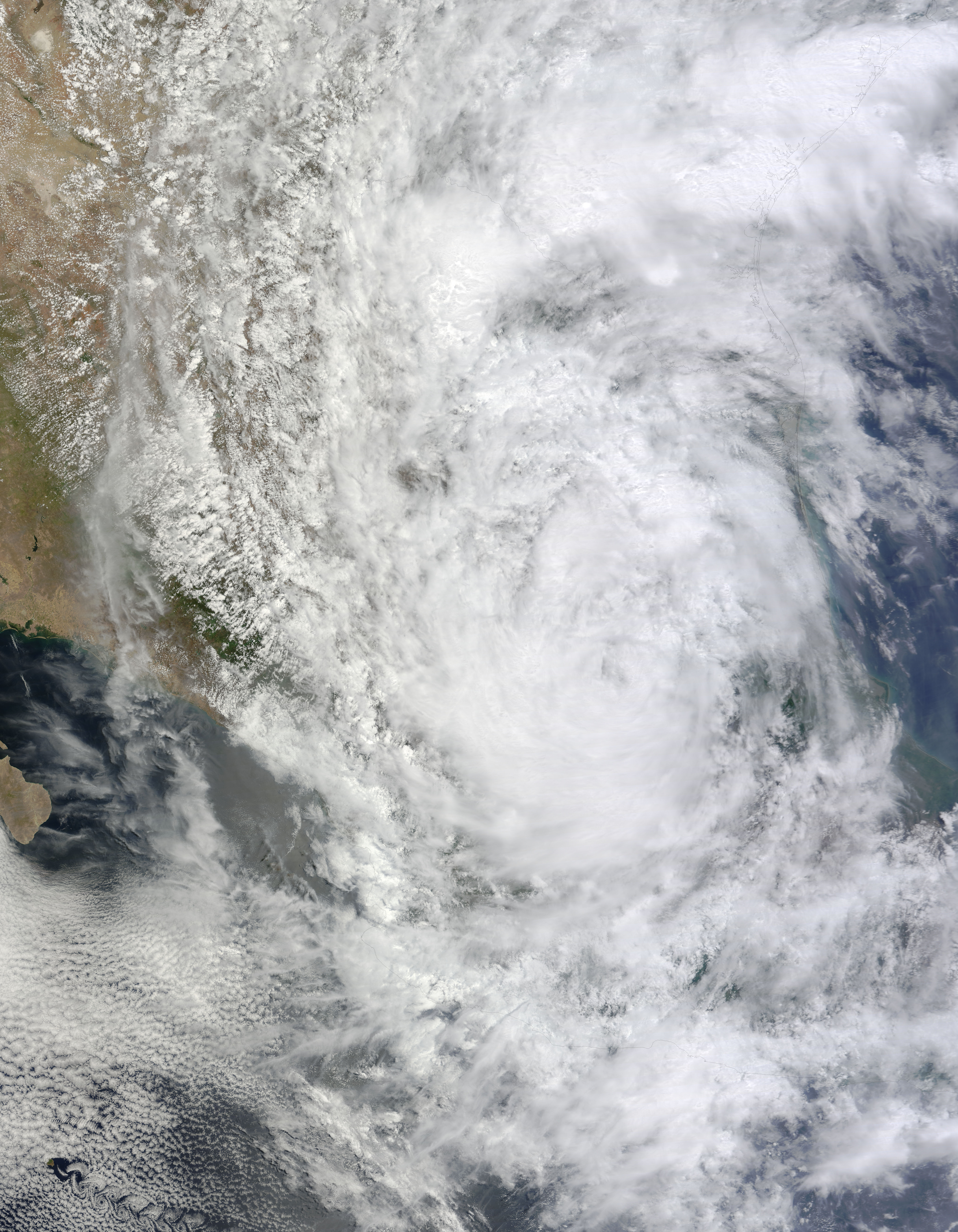
English: Alex had weakened to a tropical storm by the afternoon of July 1, 2010, the U.S. National Hurricane Center (NHC) reported. Located some 220 miles (355 kilometers) west of La Pesca, Mexico, the storm had maximum sustained winds of 40 miles (65 kilometers) per hour. Alex was expected to dissipate over Mexico’s high terrain overnight July 1–2, but was still bringing heavy rain to much of the country.
The Moderate Resolution Imaging Spectroradiometer (MODIS) on NASA’s Terra satellite captured this natural-color image of Tropical Storm Alex at 12:55 p.m. Central Daylight Time (17:55 UTC) on July 1, 2010. Storm clouds cover most of Mexico and southwestern Texas, but Alex appears less organized than it did the previous day. North is to the upper left, and black lines delineate coasts and borders. |
| Date | |
| Source | http://earthobservatory.nasa.gov/NaturalHazards/view.php?id=44514 |
| Author | NASA image by Jeff Schmaltz, MODIS Rapid Response Team at NASA GSFC. Caption by Michon Scott. |
Licensing
| This file is in the public domain in the United States because it was solely created by NASA. NASA copyright policy states that "NASA material is not protected by copyright unless noted". (See Template:PD-USGov, NASA copyright policy page or JPL Image Use Policy.) | ||
 |
Warnings:
|
File history
Click on a date/time to view the file as it appeared at that time.
| Date/Time | Thumbnail | Dimensions | User | Comment | |
|---|---|---|---|---|---|
| current | 05:26, 18 July 2015 | | 5,600 × 7,200 (4.82 MB) | Nino Marakot | Reverted to version as of 00:44, 21 June 2012 |
| 05:25, 18 July 2015 |  | 5,600 × 7,200 (4.82 MB) | Nino Marakot | Gallery | |
| 00:44, 21 June 2012 |  | 5,600 × 7,200 (4.82 MB) | Supportstorm | {{Information |Description ={{en|1=Alex had weakened to a tropical storm by the afternoon of July 1, 2010, the U.S. National Hurricane Center (NHC) reported. Located some 220 miles (355 kilometers) west of La Pesca, Mexico, the storm had maximum sus... |
File usage
The following pages on the English Wikipedia use this file (pages on other projects are not listed):