
File:Alsace Lorraine departments evolution map-en.svg

Size of this PNG preview of this SVG file: 600 × 450 pixels. Other resolutions: 320 × 240 pixels | 640 × 480 pixels | 1,024 × 768 pixels | 1,280 × 960 pixels | 2,560 × 1,920 pixels.
Original file (SVG file, nominally 600 × 450 pixels, file size: 91 KB)
| This is a file from the Wikimedia Commons. Information from its description page there is shown below. Commons is a freely licensed media file repository. You can help. |
Summary
| Description |
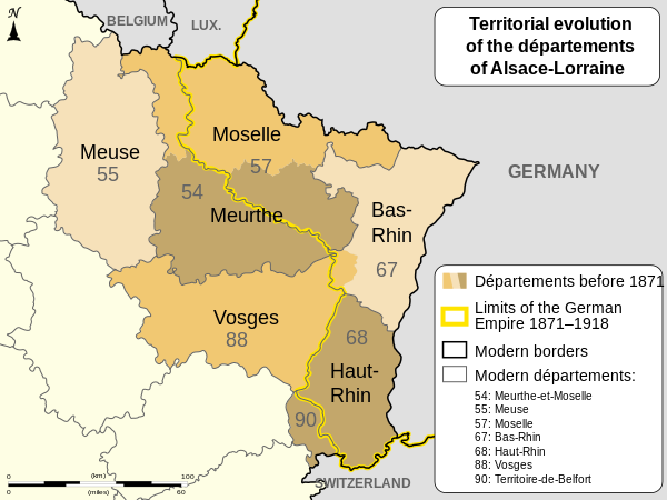
English: Changes of the boundaries of departments in Alsace and Lorraine before and after the German Empire's rule (1871-1918). Français : Évolution territoriale des départements de l'Alsace et de la Lorraine avant et après l'Empire allemand (1871-1918). |
| Date | (UTC) |
| Source | |
| Author |
|
| Other versions |
[]
|


| Camera location | | View this and other nearby images on: OpenStreetMap |
|---|

|
This SVG file contains embedded text that can be translated into your language, using any capable SVG editor, text editor or the SVG Translate tool. For more information see: About translating SVG files. |
This W3C-unspecified vector image was created with Inkscape .
W3C-validity not checked.
Licensing
I, the copyright holder of this work, hereby publish it under the following licenses:
| Copyleft: This work of art is free; you can redistribute it and/or modify it according to terms of the Free Art License. You will find a specimen of this license on the Copyleft Attitude site as well as on other sites. |
This file is licensed under the Creative Commons Attribution-Share Alike 4.0 International, 3.0 Unported, 2.5 Generic, 2.0 Generic and 1.0 Generic license.
- You are free:
- to share – to copy, distribute and transmit the work
- to remix – to adapt the work
- Under the following conditions:
- attribution – You must give appropriate credit, provide a link to the license, and indicate if changes were made. You may do so in any reasonable manner, but not in any way that suggests the licensor endorses you or your use.
- share alike – If you remix, transform, or build upon the material, you must distribute your contributions under the same or compatible license as the original.
You may select the license of your choice.
Original upload log
This image is a derivative work of the following images:
- File:Alsace_Lorraine_departments_evolution_map-fr.svg licensed with Cc-by-sa-3.0,2.5,2.0,1.0, FAL
- 2010-12-27T08:17:38Z Sémhur 600x450 (100001 Bytes) Mistake (Moselle) : 56 => 57
- 2010-12-23T17:48:20Z Sémhur 600x450 (100022 Bytes) == {{int:filedesc}} == {{Information |Description={{Multilingual description |en= Boundaries evolution of [[:en:Alsace-Lorraine|Alsace and Lorraine]]'s departments before and after [[:en:German Empire|German Empire]] (1871-19
Uploaded with derivativeFX
File history
Click on a date/time to view the file as it appeared at that time.
| Date/Time | Thumbnail | Dimensions | User | Comment | |
|---|---|---|---|---|---|
| current | 19:47, 27 August 2011 | | 600 × 450 (91 KB) | OwenBlacker | == {{int:filedesc}} == {{Information |Description={{Multilingual description |en= Changes of the boundaries of departments in Alsace and Lorraine before and after the German Empire's rule (1871-1918). |fr= Év |
File usage
The following pages on the English Wikipedia use this file (pages on other projects are not listed):
Global file usage
The following other wikis use this file:
- Usage on ar.wikipedia.org
- Usage on az.wikipedia.org
- Usage on de.wikipedia.org
- Usage on he.wikipedia.org
- Usage on ru.wikipedia.org
- Usage on sq.wikipedia.org