
File:Amelungsburg Plan.jpg

Size of this preview: 620 × 599 pixels. Other resolutions: 248 × 240 pixels | 496 × 480 pixels | 794 × 768 pixels | 1,059 × 1,024 pixels | 1,602 × 1,549 pixels.
Original file (1,602 × 1,549 pixels, file size: 1.41 MB, MIME type: image/jpeg)
| This is a file from the Wikimedia Commons. Information from its description page there is shown below. Commons is a freely licensed media file repository. You can help. |
Summary
| Description |
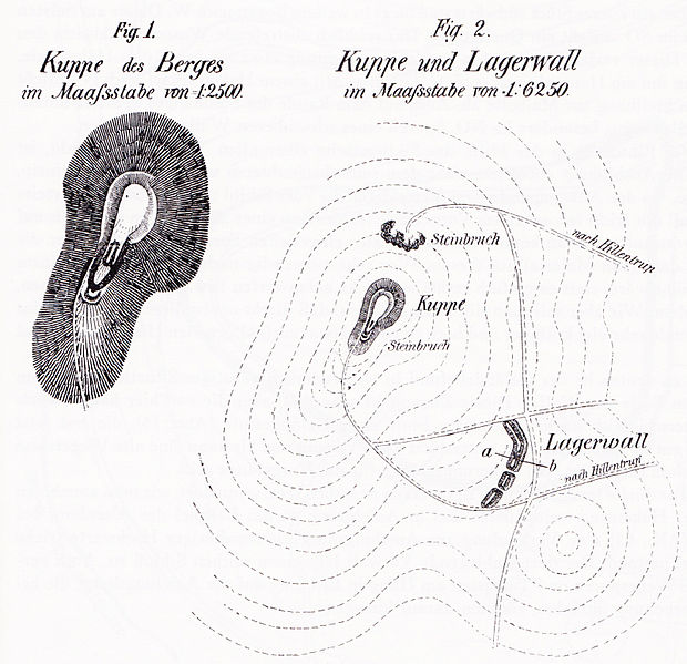
Deutsch: Lageplan der Amelungsburg bei Hillentrup (nach Ludwig Hölzermann 1830-1870) |
| Date | |
| Source | Buch: "Lokaluntersuchungen, die Kriege der Römer und Befestigungsmanieren der Germanen, Sachsen und des späteren Mittelalters betreffend", Münster 1878 |
| Author | Ludwig Hölzermann |
| Permission (Reusing this file) |
PD-old-100-1923 |
Licensing
|
This work is in the public domain in its country of origin and other countries and areas where the copyright term is the author's life plus 100 years or fewer. This work is in the public domain in the United States because it was published (or registered with the U.S. Copyright Office) before January 1, 1929. | |
| This file has been identified as being free of known restrictions under copyright law, including all related and neighboring rights. | |
[[Category:Ludwig Hölzermann}}
File history
Click on a date/time to view the file as it appeared at that time.
| Date/Time | Thumbnail | Dimensions | User | Comment | |
|---|---|---|---|---|---|
| current | 09:58, 5 October 2012 | | 1,602 × 1,549 (1.41 MB) | Oldski | {{Information |Description ={{de|1=Die Amelungsburg bei Hillentrup nach Ludwig Hölzermann (1830-1870)}} |Source =Buch von 1878 |Author =Ludwig Hölzermann |Date =1878 |Permission =PD-old-100 |other_versions = }} |
File usage
The following pages on the English Wikipedia use this file (pages on other projects are not listed):
Global file usage
The following other wikis use this file:
- Usage on de.wikipedia.org