
File:Americas Tectonic Plate Map - by NOAA.jpg

Size of this preview: 600 × 600 pixels. Other resolutions: 240 × 240 pixels | 480 × 480 pixels | 768 × 768 pixels | 1,024 × 1,024 pixels | 1,654 × 1,654 pixels.
Original file (1,654 × 1,654 pixels, file size: 419 KB, MIME type: image/jpeg)
| This is a file from the Wikimedia Commons. Information from its description page there is shown below. Commons is a freely licensed media file repository. You can help. |
Summary
| Description |
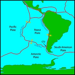
English: Map of tectonic plates around South America. Along the western coast of Chile, three of Earth’s tectonic plates intersect at the Chile Triple Junction (CTJ). Arrows show direction of relative motion of plates. |
| Date | |
| Source | https://oceanexplorer.noaa.gov/explorations/12chile/background/edu/purpose.html |
| Author | Paula Keener (NOAA) |
Licensing
This image is in the public domain because it contains materials that originally came from the U.S. National Oceanic and Atmospheric Administration, taken or made as part of an employee's official duties.
|
File history
Click on a date/time to view the file as it appeared at that time.
| Date/Time | Thumbnail | Dimensions | User | Comment | |
|---|---|---|---|---|---|
| current | 21:33, 25 January 2023 | | 1,654 × 1,654 (419 KB) | GeoWriter | Uploaded a work by Paula Keener (NOAA) from https://oceanexplorer.noaa.gov/explorations/12chile/background/edu/purpose.html with UploadWizard |
File usage
The following pages on the English Wikipedia use this file (pages on other projects are not listed):
Global file usage
The following other wikis use this file:
- Usage on hr.wikipedia.org
- Usage on tr.wikipedia.org