
File:Ancre sector 1 July 1916.png
Original file (990 × 1,240 pixels, file size: 298 KB, MIME type: image/png)
| This is a file from the Wikimedia Commons. Information from its description page there is shown below. Commons is a freely licensed media file repository. You can help. |
| Description |
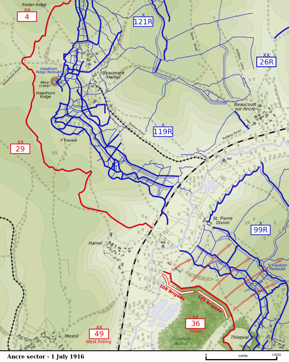
Map of the Ancre River sector of the Somme battlefield on the first day of the Battle of the Somme, 1 July 1916. British front line is shown in red. German trenches are shown in blue. German barbed wire is shown as dotted blue lines. The British divisions attacking on this sector were the British 29th Division at Beaumont Hamel and the 36th (Ulster) Division between the Ancre and Thiepval. The British 4th Division was attacking to the north towards Serre. The British 49th (West Riding) Division was in reserve. The sector was defended by the German 26th Reserve Division which had three regiments - 99th Reserve, 119th Reserve and 121st Reserve - in the front-line. The progress of the British 109th Brigade which captured the Schwaben Redoubt is shown. |
| Date | |
| Source |
Own Work by Gsl. Based on a British Ordnance Survey 1916 map (trenches as of 28 April 1916) held by the Liddle Collection. Units based on Map 9, The First Day on the Somme, Martin Middlebrook, 1971 and The Somme, Gary Sheffield, 2003. Originally uploaded to EN Wikipedia 21 November 2004 |
| Author | Gsl |
| This work has been released into the public domain by its author, Gsl at English Wikipedia. This applies worldwide. In some countries this may not be legally possible; if so: Gsl grants anyone the right to use this work for any purpose, without any conditions, unless such conditions are required by law. |
File history
Click on a date/time to view the file as it appeared at that time.
| Date/Time | Thumbnail | Dimensions | User | Comment | |
|---|---|---|---|---|---|
| current | 02:59, 11 November 2007 | | 990 × 1,240 (298 KB) | Rcbutcher | {{Information |Description=Map of the Ancre River sector of the Somme battlefield on the first day of the Battle of the Somme, 1 July 1916. British front line is shown in red. German trenches are shown in blue. German |
File usage
Global file usage
The following other wikis use this file:
- Usage on de.wikipedia.org
- Usage on fr.wikipedia.org
- Usage on nl.wikipedia.org
- Usage on pcd.wikipedia.org
- Usage on www.wikidata.org