
File:Archipel des Lavezzi.png

Size of this preview: 634 × 599 pixels. Other resolutions: 254 × 240 pixels | 508 × 480 pixels | 655 × 619 pixels.
Original file (655 × 619 pixels, file size: 463 KB, MIME type: image/png)
| This is a file from the Wikimedia Commons. Information from its description page there is shown below. Commons is a freely licensed media file repository. You can help. |
| Description |
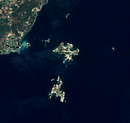
English: The Lavezzi archipelago, located southeast of mainland Corsica (France). This satellite view was acquired by Landsat 7. The two main islands are Cavallo, on the center, and Lavezzo (or Lavezzu), on the south. The other islands or islets are, from left to right : Piana, Ratino, Porraggia and Sperduto.
Français : L'archipel des Lavezzi, situé près de l'extrémité sud de la Corse (qui est visible en haut à gauche), vu par le satellite Landsat 7. Les deux îles principales sont Cavallo, au centre, et Lavezzo (ou Lavezzu), au sud. Les autres îles et îlots sont, de gauche à droite : Piana, Ratino, Porraggia et Sperduto. |
||
| Date | |||
| Source | |||
| Author | Corsica (Landsat 7) - high definition.png: NASA/USGS, Telperion | ||
| Other versions |
|
||
| Other informations |
|
.png)
| Object location | | View this and other nearby images on: OpenStreetMap |
|---|
| This file is in the public domain in the United States because it was solely created by NASA. NASA copyright policy states that "NASA material is not protected by copyright unless noted". (See Template:PD-USGov, NASA copyright policy page or JPL Image Use Policy.) | ||
 |
Warnings:
|
This work is based on a work in the public domain. It has been digitally enhanced and/or modified. This derivative work has been (or is hereby) released into the public domain by its author, Telperion. This applies worldwide.
In some countries this may not be legally possible; if so: |
| Annotations | This image is annotated: View the annotations at Commons |


.jpg)
_-_high_definition.png)
File history
Click on a date/time to view the file as it appeared at that time.
| Date/Time | Thumbnail | Dimensions | User | Comment | |
|---|---|---|---|---|---|
| current | 19:15, 24 September 2011 | | 655 × 619 (463 KB) | Telperion | {{Information |Description ={{en|1=The Lavezzi archipelago, located southeast of mainland Corsica (France). This satellite view was acquired by Landsat 7. The two main islands are |
File usage
The following pages on the English Wikipedia use this file (pages on other projects are not listed):
Global file usage
The following other wikis use this file:
- Usage on fr.wikipedia.org
- Usage on it.wikivoyage.org
- Usage on lij.wikipedia.org
- Usage on www.wikidata.org