
File:Ashland Downtown HD boundary map.png
No higher resolution available.
Ashland_Downtown_HD_boundary_map.png (634 × 507 pixels, file size: 242 KB, MIME type: image/png)
| This is a file from the Wikimedia Commons. Information from its description page there is shown below. Commons is a freely licensed media file repository. You can help. |
Summary
| Description |
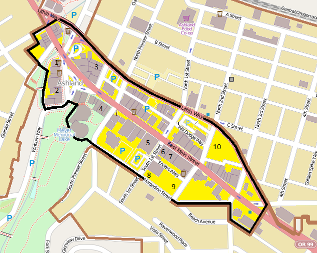
English: Map showing the boundaries of the Ashland Downtown Historic District in Ashland, Oregon, United States. The historic district is listed on the US National Register of Historic Places. Boundary data is derived from: City of Ashland (December 16, 2008) (PDF). Historic Districts (Map).
|
| Date | |
| Source | Exported screenshot from OpenStreetMap, with district boundaries and shading and some titles drawn by uploader. |
| Author |
Base map: OpenStreetMap contributors District boundaries/shading: Ian Poellet (User:Ipoellet) |
| Permission (Reusing this file) |
Base map: © OpenStreetMap contributors. Current license information available at http://www.openstreetmap.org/copyright. |
Licensing
This file is licensed under the Creative Commons Attribution-Share Alike 2.0 Generic license.
- You are free:
- to share – to copy, distribute and transmit the work
- to remix – to adapt the work
- Under the following conditions:
- attribution – You must give appropriate credit, provide a link to the license, and indicate if changes were made. You may do so in any reasonable manner, but not in any way that suggests the licensor endorses you or your use.
- share alike – If you remix, transform, or build upon the material, you must distribute your contributions under the same or compatible license as the original.
File history
Click on a date/time to view the file as it appeared at that time.
| Date/Time | Thumbnail | Dimensions | User | Comment | |
|---|---|---|---|---|---|
| current | 06:22, 17 June 2013 | | 634 × 507 (242 KB) | Ipoellet | Further color correction |
| 06:19, 17 June 2013 |  | 634 × 507 (242 KB) | Ipoellet | Correct brown outline color | |
| 06:16, 17 June 2013 |  | 634 × 507 (241 KB) | Ipoellet | User created page with UploadWizard |
File usage
The following pages on the English Wikipedia use this file (pages on other projects are not listed):
Global file usage
The following other wikis use this file:
- Usage on de.wikipedia.org