
File:Barracks at Fort Missoula.jpg

Size of this preview: 800 × 569 pixels. Other resolutions: 320 × 227 pixels | 640 × 455 pixels | 1,024 × 728 pixels | 1,280 × 910 pixels | 2,560 × 1,820 pixels | 4,575 × 3,252 pixels.
Original file (4,575 × 3,252 pixels, file size: 1.61 MB, MIME type: image/jpeg)
| This is a file from the Wikimedia Commons. Information from its description page there is shown below. Commons is a freely licensed media file repository. You can help. |
|
This is an image of a place or building that is listed on the National Register of Historic Places in the United States of America. Its reference number is 87000865. |
| Camera location | | View this and other nearby images on: OpenStreetMap |
|---|
| Description |
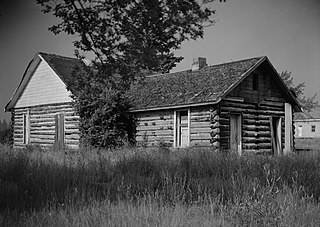
English: Northeastern side of a barracks for non-commissioned officers at Fort Missoula, located at the intersection of Reserve Street and South Avenue in Missoula, Montana, United States. Built in 1887, the fort complex is listed as the "Fort Missoula Historic District" on the National Register of Historic Places. |
|||||
| Date | ||||||
| Source | Library of Congress, Prints and Photograph Division HABS: MONT,32-MISS,2-1 | |||||
| Author | Al Huntsman | |||||
| Permission (Reusing this file) |
|


|
This image is available from the United States Library of Congress's Prints and Photographs division
under the digital ID hhh.mt0031. This tag does not indicate the copyright status of the attached work. A normal copyright tag is still required. See Commons:Licensing.
|
File history
Click on a date/time to view the file as it appeared at that time.
| Date/Time | Thumbnail | Dimensions | User | Comment | |
|---|---|---|---|---|---|
| current | 07:43, 14 April 2009 | | 4,575 × 3,252 (1.61 MB) | Cropbot | upload cropped version, operated by User:Finavon. Summary: border cropped |
| 12:07, 12 April 2009 |  | 5,000 × 3,598 (1.78 MB) | Nyttend | {{Location|46|50|34|N|114|3|16|W}} {{Information |Description={{en|Northeastern side of a barracks for {{w|non-commissioned officer|non-commissioned officers}} at {{w|Fort Missoula}}, located at the intersection of Reserve Street and South Avenue in {{w|M |
File usage
The following pages on the English Wikipedia use this file (pages on other projects are not listed):
Global file usage
The following other wikis use this file:
- Usage on www.wikidata.org