
File:Battery Cameron.jpg
Size of this preview: 800 × 323 pixels. Other resolutions: 320 × 129 pixels | 1,084 × 437 pixels.
Original file (1,084 × 437 pixels, file size: 154 KB, MIME type: image/jpeg)
| This is a file from the Wikimedia Commons. Information from its description page there is shown below. Commons is a freely licensed media file repository. You can help. |
Summary
| Description |
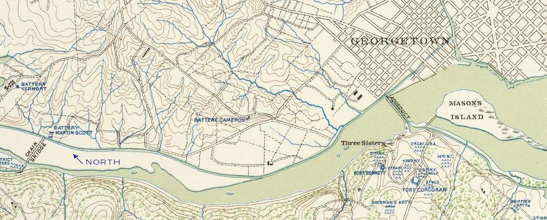
English: Map showing location of Battery Cameron, Battery Martin Scott, and Battery Vermont relative to the Chain Bridge and Aqueduct Bridge. Note the absence of Battery Kemble to the north. This image is public domain, due to its age.
Full title: Defenses of Washington. Map of the ground of occupation and defense of the Division of the U.S. Army in Virginia in command of Brig. Gen. Irvin McDowell. U.S. Coast Survey, A.D. Bache, Supdt. Topographical survey by the party in charge of H.L. Whiting, Asst., U.S.C.S. Field work executed during parts of June and July 1861, by F.W. Dorr and C. Rockwell U.S.C.S. (with) Sketch of Paducah, Ky. and vicinity by Captain John Rziha, 19th U.S. Infantry. (with) Sketch of the battle-field of Logan's Cross-roads, Ky. U.S. forces under the command of Brig. Gen. George H. Thomas. Forces of the enemy commanded by General G.B. Crittenden, Jan. 19, 1862. Drawn under the direction of Capt. Michler ... copied by A. Kilp. Sketch of the enemy's fortified position at and opposite Mill Springs, Ky., to which he retreated after his defeat at Logan's Cross-roads by the U.S. forces under Brig. Gen. George H. Thomas, Jan. 19, 1862 ... compiled ... by Edward Ruger ... drawn by A. Kilp ... Julius Bien & Co., Lith., N.Y. (1891-1895) |
||||
| Date | |||||
| Source | Atlas to accompany the official records of the Union and Confederate armies. Published under the direction of the Hons. Redfield Proctor, Stephen B. Elkins and Daniel S. Lamont, secretaries of war, by Maj. George B. Davis, U.S. Army, Mr. Leslie J. Perry, civilian expert, Mr. Joseph W. Kirkley, civilian expert, Board of Publication. Compiled by Capt. Calvin D. Cowles, 23d U.S. Infantry. Washington: Government Printing Office, 1891-1895. | ||||
| Author | Dorr, F. W.; Rockwell, Cleveland; United States. War Department; Whiting, H. L | ||||
| Permission (Reusing this file) |
|
||||
Licensing
This file is a work of a U.S. Army soldier or employee, taken or made as part of that person's official duties. As a work of the U.S. federal government, it is in the public domain in the United States.
|
 |
File history
Click on a date/time to view the file as it appeared at that time.
| Date/Time | Thumbnail | Dimensions | User | Comment | |
|---|---|---|---|---|---|
| current | 13:25, 23 March 2010 | 1,084 × 437 (154 KB) | AiNewsDesk | {{Information |Description = Map showing location of Battery Cameron, Battery Martin Scott, and Battery Vermont relative to the Chain Bridge and Aqueduct Bridge. Note the absence of Battery Kemble to the north. This image is public domain, due to it |
File usage
The following pages on the English Wikipedia use this file (pages on other projects are not listed):
Global file usage
The following other wikis use this file:
- Usage on www.wikidata.org