
File:Belgrade pashaluk.png
Size of this preview: 772 × 599 pixels. Other resolutions: 309 × 240 pixels | 618 × 480 pixels | 863 × 670 pixels.
Original file (863 × 670 pixels, file size: 69 KB, MIME type: image/png)
| This is a file from the Wikimedia Commons. Information from its description page there is shown below. Commons is a freely licensed media file repository. You can help. |
Summary
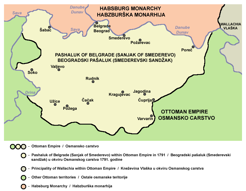
- English: Pashaluk of Belgrade (Sanjak of Smederevo) within Ottoman Empire in 1791.
- Serbian: Beogradski pašaluk (Smederevski sandžak) u okviru Osmanskog carstva 1791. godine.
- Other version: Macedonian version
Source and licence
Self-made map created by PANONIAN
| This work has been released into the public domain by its author, PANONIAN. This applies worldwide. In some countries this may not be legally possible; if so: |

|
This map has been uploaded by Electionworld from en.wikipedia.org to enable the |
References
- http://terkepek.adatbank.transindex.ro/kepek/netre/51.gif
- http://www.rodnikraj.eu/index_htm_files/255.png[dead link]
- Školski istorijski atlas, Zavod za izdavanje udžbenika SR Srbije, Beograd, 1970.
- Istorijski atlas, Geokarta, Beograd, 1999.
- Povijesni atlas, Učila - Zagreb, Zagreb, 1971.
- Denis Šehić - Demir Šehić, Istorijski atlas sveta, Beograd, 2007.
- The Times History of Europe, Times Books, London, 2002.
File history
Click on a date/time to view the file as it appeared at that time.
| Date/Time | Thumbnail | Dimensions | User | Comment | |
|---|---|---|---|---|---|
| current | 20:10, 21 September 2013 | | 863 × 670 (69 KB) | PANONIAN | aesthetics |
| 22:13, 14 October 2012 |  | 863 × 667 (69 KB) | PANONIAN | minor corrections | |
| 22:26, 13 January 2011 |  | 865 × 667 (69 KB) | PANONIAN | another attempt of solving thumbnail problem | |
| 17:05, 13 January 2011 |  | 865 × 667 (69 KB) | PANONIAN | Reverted to version as of 16:56, 13 January 2011 - trying again to fix problem. why this file is generating thumbnail from older version? | |
| 16:59, 13 January 2011 |  | 865 × 667 (69 KB) | PANONIAN | Reverted to version as of 16:56, 13 January 2011 - fixing thumbnail problem | |
| 16:58, 13 January 2011 |  | 865 × 667 (69 KB) | PANONIAN | Reverted to version as of 16:53, 13 January 2011 - fixing thumbnail problem | |
| 16:56, 13 January 2011 |  | 865 × 667 (69 KB) | PANONIAN | Reverted to version as of 16:53, 13 January 2011 - fixing thumbnail problem | |
| 16:54, 13 January 2011 |  | 756 × 552 (16 KB) | PANONIAN | Reverted to version as of 21:43, 21 December 2006 - fixing thumbnail problem | |
| 16:53, 13 January 2011 |  | 865 × 667 (69 KB) | PANONIAN | improved version | |
| 21:43, 21 December 2006 |  | 756 × 552 (16 KB) | Electionworld | {{ew|en|PANONIAN}} Self-made map by PANONIAN {{PD-user|PANONIAN}} Category:Maps of Serbia |
File usage
The following pages on the English Wikipedia use this file (pages on other projects are not listed):
Global file usage
The following other wikis use this file:
- Usage on be.wikipedia.org
- Usage on ca.wikipedia.org
- Usage on cs.wikipedia.org
- Usage on de.wikipedia.org
- Usage on el.wikipedia.org
- Usage on fr.wikipedia.org
- Usage on gl.wikipedia.org
- Usage on hr.wikipedia.org
- Usage on id.wikipedia.org
- Usage on it.wikipedia.org
- Usage on mk.wikipedia.org
- Usage on pl.wikipedia.org
- Usage on pnb.wikipedia.org
- Usage on pt.wikipedia.org
- Usage on ro.wikipedia.org
- Usage on ru.wikipedia.org
- Usage on sh.wikipedia.org
- Usage on sq.wikipedia.org
- Usage on sr.wikipedia.org
- Usage on th.wikipedia.org
- Usage on tr.wikipedia.org
- Usage on uk.wikipedia.org
- Usage on ur.wikipedia.org
- Usage on zh.wikipedia.org