
File:Boko Haram insurgency map.png

Size of this preview: 779 × 599 pixels. Other resolutions: 312 × 240 pixels | 624 × 480 pixels | 998 × 768 pixels | 1,280 × 985 pixels | 1,600 × 1,231 pixels.
Original file (1,600 × 1,231 pixels, file size: 395 KB, MIME type: image/png)
| This is a file from the Wikimedia Commons. Information from its description page there is shown below. Commons is a freely licensed media file repository. You can help. |
Summary

|
File:Boko Haram insurgency map.svg is a vector version of this file. It should be used in place of this PNG file.
File:Boko Haram insurgency map.png → File:Boko Haram insurgency map.svg
For more information, see Help:SVG. |
 |
| Description |
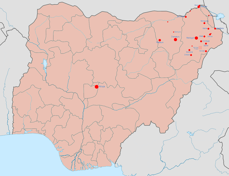
English: Map of the Boko Haram insurgency. The map image is based on Template:Nigerian insurgency detailed map.
Controlled by the Nigerian government
Controlled by Boko Haram/the Islamic State of Iraq and the Levant (variously called ISIL, ISIS, IS, Daesh) |
| Date | |
| Source | Own work |
| Author | BlueHypercane761 |
Licensing
I, the copyright holder of this work, hereby publish it under the following license:
This file is licensed under the Creative Commons Attribution-Share Alike 4.0 International license.
- You are free:
- to share – to copy, distribute and transmit the work
- to remix – to adapt the work
- Under the following conditions:
- attribution – You must give appropriate credit, provide a link to the license, and indicate if changes were made. You may do so in any reasonable manner, but not in any way that suggests the licensor endorses you or your use.
- share alike – If you remix, transform, or build upon the material, you must distribute your contributions under the same or compatible license as the original.
File history
Click on a date/time to view the file as it appeared at that time.
| Date/Time | Thumbnail | Dimensions | User | Comment | |
|---|---|---|---|---|---|
| current | 07:08, 23 January 2017 | | 1,600 × 1,231 (395 KB) | BlueHypercane761 | 1-22-2017 Update. The Nigerian Army and its allies finally annihilated Boko Haram in its last camp in Sambisa Forest (its last known stronghold), on December 24, 2016, reducing Boko Haram to a weakened, insurgent group. |
| 23:41, 6 July 2016 |  | 1,600 × 1,231 (395 KB) | BlueHypercane761 | 7-6-2016 Update. The Nigerian Army and the Chadian Army completely sealed off the Sambisa Forest region on June 9, 2016, and have captured 50% of the forest. | |
| 22:09, 25 December 2015 |  | 1,600 × 1,231 (395 KB) | BlueHypercane761 | 12-25-2015 Update. The Nigerian Army has pushed into the heart of Sambisa Forest. | |
| 06:43, 12 November 2015 |  | 1,600 × 1,231 (395 KB) | BlueHypercane761 | Update for 11-12-2015. Boko Haram's territorial control was reduced to Sambisa Forest on Septemebr 8, 2015. The situation is current as of November 12, 2015. | |
| 06:28, 12 November 2015 |  | 1,600 × 1,231 (395 KB) | BlueHypercane761 | User created page with UploadWizard |
File usage
The following pages on the English Wikipedia use this file (pages on other projects are not listed):
Global file usage
The following other wikis use this file:
- Usage on es.wikipedia.org
- Usage on ga.wikipedia.org
- Usage on id.wikipedia.org
- Usage on ko.wikipedia.org