
File:Bridge 32, Clark's Bridge - geograph.org.uk - 944763.jpg
No higher resolution available.
Bridge_32,_Clark's_Bridge_-_geograph.org.uk_-_944763.jpg (640 × 453 pixels, file size: 119 KB, MIME type: image/jpeg)
| This is a file from the Wikimedia Commons. Information from its description page there is shown below. Commons is a freely licensed media file repository. You can help. |
Summary
| Description |
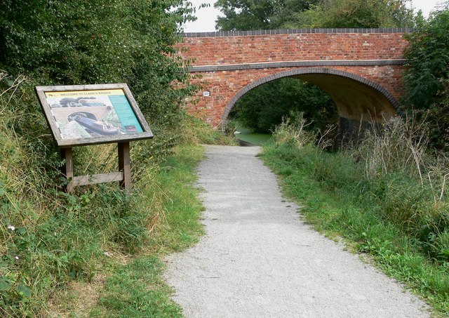
English: Bridge 32: Clark's Bridge The bridge and information board are located along the Grantham Canal, east of Hickling. The information board states:
Clark's Bridge is typical of those on the Grantham. Built in the late 1700s from red handmade bricks, it probably had stone copings. The blue brick copings you see today were added later. The bridge's surface is grass, forming an access track to nearby fields. Permission to build the canal was probably dependent on this type of access bridge being included. Many bridge numbers on the canal are hand painted. Clark's Bridge also has a hand painted nameplate. Both features can be seen from the towpath. |
| Date | |
| Source | From geograph.org.uk |
| Author | Mat Fascione |
| Attribution (required by the license) | Mat Fascione / Bridge 32: Clark's Bridge / |
This is a photo of listed building number 1235901. |
| Camera location | | View this and other nearby images on: OpenStreetMap |
|---|
_heading:90.00&language=en)
| Object location | | View this and other nearby images on: OpenStreetMap |
|---|
_heading:90.00&language=en)
Licensing

|
This image was taken from the Geograph project collection. See this photograph's page on the Geograph website for the photographer's contact details. The copyright on this image is owned by Mat Fascione and is licensed for reuse under the Creative Commons Attribution-ShareAlike 2.0 license.
|
This file is licensed under the Creative Commons Attribution-Share Alike 2.0 Generic license.
Attribution: Mat Fascione
- You are free:
- to share – to copy, distribute and transmit the work
- to remix – to adapt the work
- Under the following conditions:
- attribution – You must give appropriate credit, provide a link to the license, and indicate if changes were made. You may do so in any reasonable manner, but not in any way that suggests the licensor endorses you or your use.
- share alike – If you remix, transform, or build upon the material, you must distribute your contributions under the same or compatible license as the original.
File history
Click on a date/time to view the file as it appeared at that time.
| Date/Time | Thumbnail | Dimensions | User | Comment | |
|---|---|---|---|---|---|
| current | 09:21, 22 February 2011 | | 640 × 453 (119 KB) | GeographBot | == {{int:filedesc}} == {{Information |description={{en|1=Bridge 32: Clark's Bridge The bridge and information board are located along the Grantham Canal, east of Hickling. The information board states: Clark's Bridge is typical of those on the Grantham. |
File usage
The following pages on the English Wikipedia use this file (pages on other projects are not listed):
Global file usage
The following other wikis use this file:
- Usage on www.wikidata.org