
File:Buckshaw Hall - geograph.org.uk - 1097081.jpg
No higher resolution available.
Buckshaw_Hall_-_geograph.org.uk_-_1097081.jpg (640 × 480 pixels, file size: 98 KB, MIME type: image/jpeg)
| This is a file from the Wikimedia Commons. Information from its description page there is shown below. Commons is a freely licensed media file repository. You can help. |
Summary
| Description |
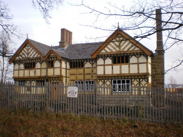
English: Buckshaw Hall. Was built in 1650s by the Robinson family.This two storey timber hall had its central part flanked by two protruding gables, one at each end with two brick chimneys built into northerly and southerly elevations. The hall stayed in private possession until around 1937 when it was purchased, with the accompanying farmland, by the R.O.F. to build a munitions factory. Nearing its complete restoration, the hall will eventually be sold. Link to a photo circa 2005 18039 |
| Date | |
| Source | From geograph.org.uk |
| Author | Alexander P Kapp |
| Attribution (required by the license) | Alexander P Kapp / Buckshaw Hall / |
| Camera location | | View this and other nearby images on: OpenStreetMap |
|---|
_heading:90.00&language=en)
| Object location | | View this and other nearby images on: OpenStreetMap |
|---|
_heading:90.00&language=en)
Licensing

|
This image was taken from the Geograph project collection. See this photograph's page on the Geograph website for the photographer's contact details. The copyright on this image is owned by Alexander P Kapp and is licensed for reuse under the Creative Commons Attribution-ShareAlike 2.0 license.
|
This file is licensed under the Creative Commons Attribution-Share Alike 2.0 Generic license.
Attribution: Alexander P Kapp
- You are free:
- to share – to copy, distribute and transmit the work
- to remix – to adapt the work
- Under the following conditions:
- attribution – You must give appropriate credit, provide a link to the license, and indicate if changes were made. You may do so in any reasonable manner, but not in any way that suggests the licensor endorses you or your use.
- share alike – If you remix, transform, or build upon the material, you must distribute your contributions under the same or compatible license as the original.
File history
Click on a date/time to view the file as it appeared at that time.
| Date/Time | Thumbnail | Dimensions | User | Comment | |
|---|---|---|---|---|---|
| current | 13:40, 24 February 2011 | | 640 × 480 (98 KB) | GeographBot | == {{int:filedesc}} == {{Information |description={{en|1=Buckshaw Hall Was built in 1650's by the Robinson family.This two storey timber hall had its central part flanked by two protruding gables, one at each end with two brick chimneys built into norther |
File usage
The following pages on the English Wikipedia use this file (pages on other projects are not listed):
Global file usage
The following other wikis use this file:
- Usage on dag.wikipedia.org
- Usage on da.wikipedia.org
- Usage on www.wikidata.org