
File:Cape Corwin.PNG
No higher resolution available.
Cape_Corwin.PNG (412 × 293 pixels, file size: 196 KB, MIME type: image/png)
| This is a file from the Wikimedia Commons. Information from its description page there is shown below. Commons is a freely licensed media file repository. You can help. |
| Description |
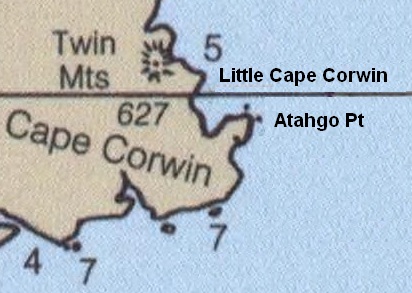
English: Detail from Bering Sea nautical chart showing Nunivak Island and surrounding area. |
| Date | (UTC) |
| Source | |
| Author |
|
| This is a retouched picture, which means that it has been digitally altered from its original version. Modifications: deleted some labels and added others; cropped. The original can be viewed here: Nunivak 2000 USCGS.PNG:
|
This image is in the public domain because it contains materials that originally came from the U.S. National Oceanic and Atmospheric Administration, taken or made as part of an employee's official duties.
|
Original upload log
This image is a derivative work of the following images:
- File:Nunivak_2000_USCGS.PNG licensed with PD-USGov-NOAA
- 2009-09-11T03:45:16Z Dankarl 897x549 (1048732 Bytes) {{Information |Description={{en|1=Detail from Bering Sea nautical chart showing Nunivak Island and surrounding area.}} |Source=Historical Maps and Charts Project http://historicalcharts.noaa.gov/tiled_jpgs_done/zoomifyURLDriv
Little Cape Corwin and Atahgo Point labels added; several depth-indicators (labels and the blue-white contour) deleted to simplify and make room.
Uploaded with derivativeFX
File history
Click on a date/time to view the file as it appeared at that time.
| Date/Time | Thumbnail | Dimensions | User | Comment | |
|---|---|---|---|---|---|
| current | 03:53, 11 September 2009 | | 412 × 293 (196 KB) | Dankarl | {{Information |Description={{en|1=Detail from Bering Sea nautical chart showing Nunivak Island and surrounding area.}} |Source=*File:Nunivak_2000_USCGS.PNG |Date=2009-09-11 03:51 (UTC) |Author=*File:Nunivak_2000_USCGS.PNG: Office of Coast Surv |
File usage
The following pages on the English Wikipedia use this file (pages on other projects are not listed):