
File:Carte Distribution des villages d'Empire.png

Size of this preview: 800 × 490 pixels. Other resolutions: 320 × 196 pixels | 640 × 392 pixels | 1,024 × 627 pixels | 1,280 × 784 pixels | 2,853 × 1,747 pixels.
Original file (2,853 × 1,747 pixels, file size: 1.32 MB, MIME type: image/png)
| This is a file from the Wikimedia Commons. Information from its description page there is shown below. Commons is a freely licensed media file repository. You can help. |
Summary
| Description |
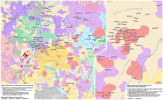
Deutsch: Karte: Verteilung der Reichsdörfer und Reichsweiler im Heiligen Römischen Reich
English: Map: Imperial Village distribution in the Holy Roman Empire
Français : Carte: Distribution des villages d'Empire dans le Saint Empire romain germanique |
| Date | see file history |
| Source | Own work using: Karte des Heiligen Römischen Reichs 1618 by Sir Iain |
| Author | Maximilian Dörrbecker (Chumwa) |
| Permission (Reusing this file) |
I, the copyright holder of this work, hereby publish it under the following license: This file is licensed under the Creative Commons Attribution-Share Alike 2.5 Generic license.
Sie dürfen das Bild zu den folgenden Bedingungen nutzen:
|
| Other versions |
|


_-_DE.svg)
File history
Click on a date/time to view the file as it appeared at that time.
| Date/Time | Thumbnail | Dimensions | User | Comment | |
|---|---|---|---|---|---|
| current | 07:57, 3 December 2017 | | 2,853 × 1,747 (1.32 MB) | Chumwa | == {{int:filedesc}} == {{Information | Description = {{de|1=Karte: Verteilung der Reichsdörfer und Reichsweiler im Heiligen Römischen Reich}} {{en|1=Map: Imperial Village distribution in the Holy Roman Empire}} {{fr|1=Carte: Distribution des village... |
File usage
The following pages on the English Wikipedia use this file (pages on other projects are not listed):
Global file usage
The following other wikis use this file:
- Usage on fr.wikipedia.org
- Usage on www.wikidata.org