
File:Catterick Bridge station (remains) geograph-3147653-by-Ben-Brooksbank.jpg
Size of this preview: 800 × 480 pixels. Other resolutions: 320 × 192 pixels | 1,024 × 615 pixels | 1,280 × 768 pixels | 2,391 × 1,435 pixels.
Original file (2,391 × 1,435 pixels, file size: 333 KB, MIME type: image/jpeg)
| This is a file from the Wikimedia Commons. Information from its description page there is shown below. Commons is a freely licensed media file repository. You can help. |
_geograph-3147653-by-Ben-Brooksbank.jpg)
Summary
| Description |
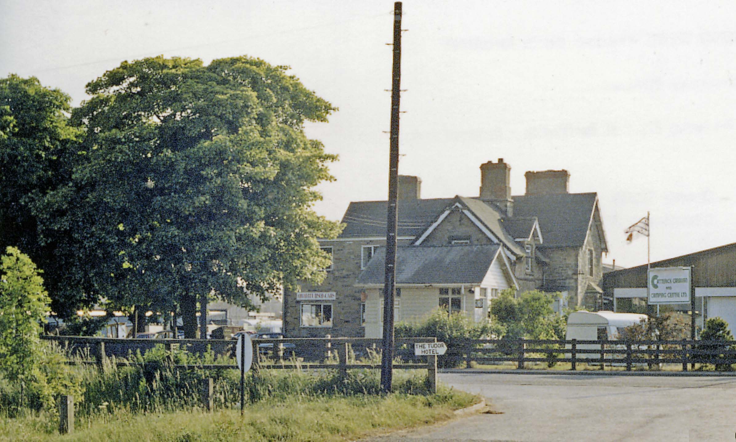
English: Catterick Bridge station (remains), 1988. View westward, towards Richmond: ex-NER (Darlington) - Eryholme Junction - Richmond line. The station, also the Catterick Military Railway which branched off to the SW, served the vast Military Camp - the largest of the British Army, with 12,000 men - and therefore important, even after World War Two, the branch seeing regular Troop and Leave trains. However, it and the line to Richmond were closed to passengers from 3/3/69 and to goods from 9/2/70. The track, now a roadway, was lifted in October 1970. (The Goods Yard was the scene of a major explosion of ammunition in February 1944). |
| Date | |
| Source | From geograph.org.uk |
| Author | Ben Brooksbank |
| Permission (Reusing this file) |
Creative Commons Attribution Share-alike license 2.0 |
| Attribution (required by the license) | Ben Brooksbank / Catterick Bridge station (remains), 1988 / |
| Camera location | | View this and other nearby images on: OpenStreetMap |
|---|
_geograph-3147653-by-Ben-Brooksbank.jpg¶ms=054.388952_N_-001.651638_E_globe:Earth_type:camera_heading:157.00&language=en)
Licensing

|
This image was taken from the Geograph project collection. See this photograph's page on the Geograph website for the photographer's contact details. The copyright on this image is owned by Ben Brooksbank and is licensed for reuse under the Creative Commons Attribution-ShareAlike 2.0 license.
|
This file is licensed under the Creative Commons Attribution-Share Alike 2.0 Generic license.
Attribution: Ben Brooksbank
- You are free:
- to share – to copy, distribute and transmit the work
- to remix – to adapt the work
- Under the following conditions:
- attribution – You must give appropriate credit, provide a link to the license, and indicate if changes were made. You may do so in any reasonable manner, but not in any way that suggests the licensor endorses you or your use.
- share alike – If you remix, transform, or build upon the material, you must distribute your contributions under the same or compatible license as the original.
File history
Click on a date/time to view the file as it appeared at that time.
| Date/Time | Thumbnail | Dimensions | User | Comment | |
|---|---|---|---|---|---|
| current | 19:03, 6 October 2012 | | 2,391 × 1,435 (333 KB) | Chevin | == {{int:filedesc}} == {{Information |Description={{en|1='''Catterick Bridge station (remains), 1988.'''<br/> View westward, towards Richmond: ex-NER (Darlington) - Eryholme Junction - Richmond line. The station, also the Catterick Military Railway whi... |
File usage
The following pages on the English Wikipedia use this file (pages on other projects are not listed):
Global file usage
The following other wikis use this file:
- Usage on www.wikidata.org
_geograph-3147653-by-Ben-Brooksbank.jpg)