
File:Channel Islands kelp beds 2013.jpg
Channel_Islands_kelp_beds_2013.jpg (720 × 480 pixels, file size: 288 KB, MIME type: image/jpeg)
| This is a file from the Wikimedia Commons. Information from its description page there is shown below. Commons is a freely licensed media file repository. You can help. |
| Description |
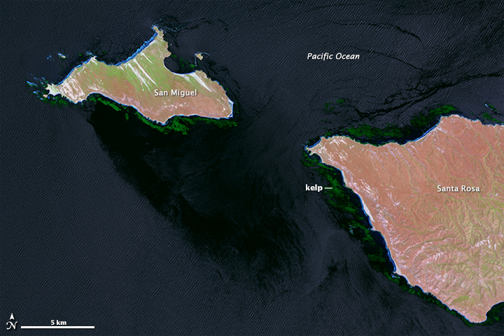
English: The natural color (top) and near-infrared (bottom) images at the top of this page show the kelp-rich waters around California’s Channel Islands, as observed on May 20, 2013, by the Operational Land Imager on Landsat 8. Wave patterns are visible on the water surface in both images, as is the water and wind shadow on the southeast side of San Miguel, where the ocean surface is smoother. The kelp are very difficult to spot in natural color, but a combination of near-infrared and natural color (bands 6-5-4) helps them stand out (second image). Turn on the image comparison tool to highlight the kelp.
Landsat measures the energy reflected and emitted from Earth at many different wavelengths. Knowing how features on Earth reflect or absorb energy at certain wavelengths helps scientists map and measure changes to the surface. The most important feature for the kelp researchers is Landsat’s near-infrared band, which measures wavelengths of light that are just outside of our visual range. Healthy vegetation strongly reflects near-infrared energy, so this band is often used in plant studies. Also, water absorbs a lot of near-infrared energy and reflects little, making the band particularly good for mapping boundaries between land and water. “The near-infrared is key for identifying kelp from surrounding water,” said Kyle Cavanaugh, a marine biologist who uses remote sensing. “Like other types of photosynthesizing vegetation, giant kelp have high reflectance in the near infrared. This makes the kelp canopy really stand out from the surrounding water.” |
|||||
| Date | ||||||
| Source | http://earthobservatory.nasa.gov/IOTD/view.php?id=85023&src=eoa-iotd | |||||
| Author | NASA Earth Observatory image by Mike Taylor and Jesse Allen | |||||
| Permission (Reusing this file) |
|

File history
Click on a date/time to view the file as it appeared at that time.
| Date/Time | Thumbnail | Dimensions | User | Comment | |
|---|---|---|---|---|---|
| current | 15:58, 9 January 2015 | | 720 × 480 (288 KB) | Tillman | {{Information |Description ={{en|1=The natural color (top) and near-infrared (bottom) images at the top of this page show the kelp-rich waters around California’s Channel Islands, as observed on May 20, 2013, by the Operational Land Imager on Land... |