
File:CircumnavigationByGeorgeAnson EN.svg

Size of this PNG preview of this SVG file: 800 × 443 pixels. Other resolutions: 320 × 177 pixels | 640 × 354 pixels | 1,024 × 567 pixels | 1,280 × 709 pixels | 2,560 × 1,418 pixels | 2,488 × 1,378 pixels.
Original file (SVG file, nominally 2,488 × 1,378 pixels, file size: 4.14 MB)
| This is a file from the Wikimedia Commons. Information from its description page there is shown below. Commons is a freely licensed media file repository. You can help. |
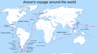
| Description | George Anson's voyage |
| Date | |
| Source | From English Wikipedia: "Peter4Truth Land outline taken from diagram created for Magellan's circumnavigation (http://en.wikipedia.org/wiki/Image:Magellan%27s_voyage_EN.svg) that is described as "Own work, copyleft: Multi-license with GFDL and Creative Commons CC-BY-SA-2.5 and older versions (2.0 and 1.0)" and then I added new labels and path of the ship based on Anson's chart circa 1745 that you can see here http://www.pbagalleries.com/img/161310_sp1f.jpg (I'm not sure if it is OK to upload this photo of the chart)." |
| Author | Peter4Truth |
| Permission (Reusing this file) |
Copyleft |
| Other versions | Derivative works of this file: CircumnavigationByGeorgeAnson ES.svg |
This file is licensed under the Creative Commons Attribution-Share Alike 2.5 Generic license.
- You are free:
- to share – to copy, distribute and transmit the work
- to remix – to adapt the work
- Under the following conditions:
- attribution – You must give appropriate credit, provide a link to the license, and indicate if changes were made. You may do so in any reasonable manner, but not in any way that suggests the licensor endorses you or your use.
- share alike – If you remix, transform, or build upon the material, you must distribute your contributions under the same or compatible license as the original.
File history
Click on a date/time to view the file as it appeared at that time.
| Date/Time | Thumbnail | Dimensions | User | Comment | |
|---|---|---|---|---|---|
| current | 02:44, 20 July 2009 | | 2,488 × 1,378 (4.14 MB) | Ukas | {{Information |Description=George Anson's voyage |Source=From English Wikipedia: "Peter4Truth Land outline taken from diagram created for Magellan's circumnavigation (http://en.wikipedia.org/wiki/Image:Magellan%27s_voyage_EN.svg) that is described as "Own |
File usage
The following pages on the English Wikipedia use this file (pages on other projects are not listed):