
File:Clowne South station geograph-3086073-by-Ben-Brooksbank.jpg

Size of this preview: 800 × 358 pixels. Other resolutions: 320 × 143 pixels | 898 × 402 pixels.
Original file (898 × 402 pixels, file size: 528 KB, MIME type: image/jpeg)
| This is a file from the Wikimedia Commons. Information from its description page there is shown below. Commons is a freely licensed media file repository. You can help. |
Summary
| Description |
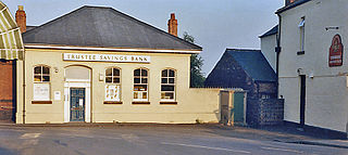
English: Former Clowne South station View NE, towards Beighton and Sheffield (Victoria) (left), Langwith Junction, Shirebrook etc. right: ex-GC (Lancashire, Derbyshire & East Coast section), Beighton - Langwith branch. The line lost its passenger service (Mansfield LMS - Shirebrook North - Treeton - Sheffield LMS) from 10/9/39 and this was the booking-office. The station, which was very close to the ex-Midland station, was named Clown (no 'e') & Barlbrough, but on 18/6/51 it was renamed 'Clowne South' and the line remained open for excursions and diverted GC Main line trains as well as freight until 4/7/60. |
| Date | |
| Source | From geograph.org.uk |
| Author | Ben Brooksbank |
| Permission (Reusing this file) |
Creative Commons Attribution Share-alike license 2.0 |
| Attribution (required by the license) | Ben Brooksbank / Former Clowne South station / |
| Camera location | | View this and other nearby images on: OpenStreetMap |
|---|
Licensing

|
This image was taken from the Geograph project collection. See this photograph's page on the Geograph website for the photographer's contact details. The copyright on this image is owned by Ben Brooksbank and is licensed for reuse under the Creative Commons Attribution-ShareAlike 2.0 license.
|
This file is licensed under the Creative Commons Attribution-Share Alike 2.0 Generic license.
Attribution: Ben Brooksbank
- You are free:
- to share – to copy, distribute and transmit the work
- to remix – to adapt the work
- Under the following conditions:
- attribution – You must give appropriate credit, provide a link to the license, and indicate if changes were made. You may do so in any reasonable manner, but not in any way that suggests the licensor endorses you or your use.
- share alike – If you remix, transform, or build upon the material, you must distribute your contributions under the same or compatible license as the original.
File history
Click on a date/time to view the file as it appeared at that time.
| Date/Time | Thumbnail | Dimensions | User | Comment | |
|---|---|---|---|---|---|
| current | 12:07, 2 September 2012 | | 898 × 402 (528 KB) | Chevin | == {{int:filedesc}} == {{Information |Description={{en|1='''Former Clowne South station'''<br/> View NE, towards Beighton and Sheffield (Victoria) (left), Langwith Junction, Shirebrook etc. right: ex-GC (Lancashire, Derbyshire & East Coast section), Be... |
File usage
The following pages on the English Wikipedia use this file (pages on other projects are not listed):
Global file usage
The following other wikis use this file:
- Usage on www.wikidata.org