
File:Continental pole of inaccessibility.png

Size of this preview: 600 × 600 pixels. Other resolutions: 240 × 240 pixels | 480 × 480 pixels | 960 × 960 pixels.
Original file (960 × 960 pixels, file size: 152 KB, MIME type: image/png)
| This is a file from the Wikimedia Commons. Information from its description page there is shown below. Commons is a freely licensed media file repository. You can help. |
Summary

|
This map image could be re-created using vector graphics as an SVG file. This has several advantages; see Commons:Media for cleanup for more information. If an SVG form of this image is available, please upload it and afterwards replace this template with
{{vector version available|new image name}}.
It is recommended to name the SVG file “Continental pole of inaccessibility.svg”—then the template Vector version available (or Vva) does not need the new image name parameter. |
| Description |
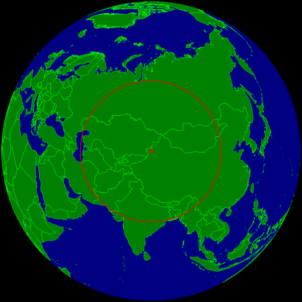
English: Spherical Earth centered on the continental pole of inaccessibility in the middle of Eurasia. The circle indicates the distance to the nearest ocean (the Caspian Sea on the left is not connected with the ocean).
Deutsch: Erdkugel, zentriert auf dem kontinentalen Pol der Unzugänglichkeit in der Mitte von Eurasien. Der Kreis zeigt den Abstand zum nächsten Ozean (das Kaspische Meer links im Bild ist nicht mit dem Ozean verbunden). |
| Date | |
| Source | Own work |
| Author | Timwi |
Licensing
| I, the copyright holder of this work, release this work into the public domain. This applies worldwide. In some countries this may not be legally possible; if so: I grant anyone the right to use this work for any purpose, without any conditions, unless such conditions are required by law. |
File history
Click on a date/time to view the file as it appeared at that time.
| Date/Time | Thumbnail | Dimensions | User | Comment | |
|---|---|---|---|---|---|
| current | 10:20, 24 March 2015 | | 960 × 960 (152 KB) | RokerHRO | optipng -o7 -i0 → 29.75% decrease |
| 23:35, 25 July 2008 |  | 960 × 960 (216 KB) | Timwi | {{Information |Description={{en|1=Spherical Earth centered on the continental pole of inaccessibility in the middle of Eurasia. The circle indicates the distance to the nearest ocean (the body of water on the left is not co |
File usage
The following pages on the English Wikipedia use this file (pages on other projects are not listed):
Global file usage
The following other wikis use this file:
- Usage on ast.wikipedia.org
- Usage on ca.wikipedia.org
- Usage on de.wikipedia.org
- Usage on es.wikipedia.org
- Usage on et.wikipedia.org
- Usage on frr.wikipedia.org
- Usage on fr.wikipedia.org
- Usage on it.wikipedia.org
- Usage on ja.wikipedia.org
- Usage on lb.wikipedia.org
- Usage on pl.wikipedia.org
- Usage on pt.wikipedia.org
- Usage on ro.wikipedia.org
- Usage on sk.wikipedia.org
- Usage on uk.wikipedia.org
- Usage on vi.wikipedia.org
- Usage on www.wikidata.org
- Usage on zh.wikipedia.org