
File:CoochsBridge1777.jpg

Size of this preview: 728 × 600 pixels. Other resolutions: 292 × 240 pixels | 583 × 480 pixels | 933 × 768 pixels | 1,244 × 1,024 pixels | 2,516 × 2,072 pixels.
Original file (2,516 × 2,072 pixels, file size: 1.13 MB, MIME type: image/jpeg)
| This is a file from the Wikimedia Commons. Information from its description page there is shown below. Commons is a freely licensed media file repository. You can help. |
Summary
| Description |
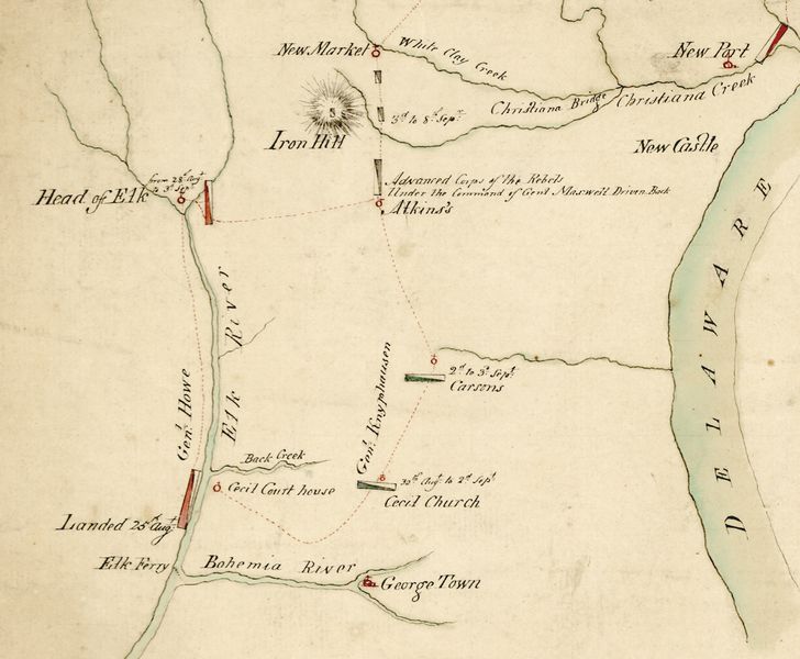
English: Detail of a period military map depicting the preliminary British movements in the 1777 Philadelphia campaign in Maryland and Delaware, including the site (near Iron Hill) of the Battle of Cooch's Bridge. |
||||||||||||||||||||
| Date | circa 1777 | ||||||||||||||||||||
| Source |
|
||||||||||||||||||||
| Author |
|
||||||||||||||||||||


Licensing
|
This work is in the public domain in its country of origin and other countries and areas where the copyright term is the author's life plus 100 years or fewer. | |
| This file has been identified as being free of known restrictions under copyright law, including all related and neighboring rights. | |
File history
Click on a date/time to view the file as it appeared at that time.
| Date/Time | Thumbnail | Dimensions | User | Comment | |
|---|---|---|---|---|---|
| current | 16:46, 12 August 2010 | | 2,516 × 2,072 (1.13 MB) | Magicpiano | {{Information |Description={{en|Detail of a period military map depicting the preliminary British movements in the 1777 w:Philadelphia campaign in Maryland and Delaware, including the site (near Iron Hill) of the w:Battle of Cooch's Bridge.}} |S |
File usage
The following pages on the English Wikipedia use this file (pages on other projects are not listed):
Global file usage
The following other wikis use this file:
- Usage on ja.wikipedia.org
- Usage on pl.wikipedia.org
- Usage on ru.wikipedia.org
- Usage on www.wikidata.org