
File:Copperplate map St Brides.jpg
No higher resolution available.
Copperplate_map_St_Brides.jpg (210 × 245 pixels, file size: 42 KB, MIME type: image/jpeg)
| This is a file from the Wikimedia Commons. Information from its description page there is shown below. Commons is a freely licensed media file repository. You can help. |
Summary
| Description |
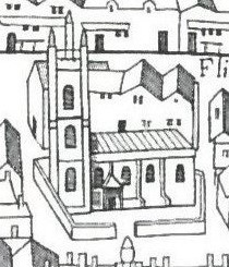
English: Detail from the "Copperplate" map of London, surveyed 1553-9, showing St Bride's Church. |
| Date | circa 1553 |
| Source | Ann Saunders and John Schofield (eds), Tudor London: a map and a view (2001) |
| Author | Unknown author |
Licensing
|
This work is in the public domain in its country of origin and other countries and areas where the copyright term is the author's life plus 70 years or fewer. This work is in the public domain in the United States because it was published (or registered with the U.S. Copyright Office) before January 1, 1929. | |
| This file has been identified as being free of known restrictions under copyright law, including all related and neighboring rights. | |
File history
Click on a date/time to view the file as it appeared at that time.
| Date/Time | Thumbnail | Dimensions | User | Comment | |
|---|---|---|---|---|---|
| current | 16:09, 10 May 2015 | | 210 × 245 (42 KB) | GrindtXX | User created page with UploadWizard |
File usage
The following pages on the English Wikipedia use this file (pages on other projects are not listed):
Global file usage
The following other wikis use this file:
- Usage on fa.wikipedia.org
- Usage on ml.wikipedia.org
- Usage on pt.wikipedia.org