
File:Crater-depth-diagram.png
No higher resolution available.
Crater-depth-diagram.png (370 × 139 pixels, file size: 2 KB, MIME type: image/png)
| This is a file from the Wikimedia Commons. Information from its description page there is shown below. Commons is a freely licensed media file repository. You can help. |
Summary
| Description |
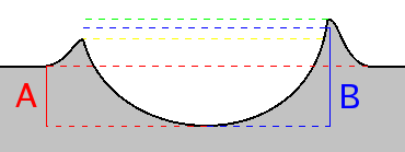
This is a diagram intended to show that the depth of a crater can be measured either from the local surface or the height of the rim. Depth "A" measures from the surface to the bottom of the crater. Depth "B" measures from the mean height of the rim to the bottom of the crater. This image was created through Gimp 2.2.6.
|
|||
| Source | Own work | |||
| Author | Beland | |||
| Other versions | Derivative works of this file: Crater depth diagram.svg |

Licensing
| I, the copyright holder of this work, release this work into the public domain. This applies worldwide. In some countries this may not be legally possible; if so: I grant anyone the right to use this work for any purpose, without any conditions, unless such conditions are required by law. |
Original upload log
| Date/Time | Dimensions | User | Comment |
|---|---|---|---|
| 2 July 2005, 20:23:43 | 370 × 139 (2807 bytes) | Beland (talk · contribs) | This is a diagram intended to show that the depth of a crater can be measured either from the local surface or the height of the rim. Depth "A" measures from the surface to the bottom of the crater. Depth "B" measures from the ''mean'' height of the rim |
File history
Click on a date/time to view the file as it appeared at that time.
| Date/Time | Thumbnail | Dimensions | User | Comment | |
|---|---|---|---|---|---|
| current | 18:44, 3 December 2014 | 370 × 139 (2 KB) | GifTagger | Bot: Converting file to superior PNG file. (Source: Crater-depth-diagram.gif). This GIF was problematic due to non-greyscale color table. |
File usage
The following pages on the English Wikipedia use this file (pages on other projects are not listed):