
File:CrossHarborRailTunnelMap.png
No higher resolution available.
CrossHarborRailTunnelMap.png (415 × 349 pixels, file size: 20 KB, MIME type: image/png)
| This is a file from the Wikimedia Commons. Information from its description page there is shown below. Commons is a freely licensed media file repository. You can help. |
| This image appeared on Wikipedia's Main Page in the Did you know? column on 21 May 2006 (see archives). |
Summary
| Description |
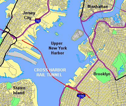
English: Map showing Upper New York Harbor with alignment of proposed Cross-Harbor Rail Tunnel shown on map by Cross Harbor Freight Movement Project superimposed and legends added by hand. |
| Source | Bureau TIGER map browser |
| Author | U.S. Census, Craig Bolon |
Licensing
This image or file is a work of a United States Census Bureau employee, taken or made as part of that person's official duties. As a work of the U.S. federal government, the image is in the public domain.
|
 |
(base map)
| This file is licensed under the Creative Commons Attribution-Share Alike 3.0 Unported license. Subject to disclaimers. | ||
| ||
| This licensing tag was added to this file as part of the GFDL licensing update. |

|
Permission is granted to copy, distribute and/or modify this document under the terms of the GNU Free Documentation License, Version 1.2 or any later version published by the Free Software Foundation; with no Invariant Sections, no Front-Cover Texts, and no Back-Cover Texts. A copy of the license is included in the section entitled GNU Free Documentation License. Subject to disclaimers. |
(enhancements)
File history
Click on a date/time to view the file as it appeared at that time.
| Date/Time | Thumbnail | Dimensions | User | Comment | |
|---|---|---|---|---|---|
| current | 18:25, 21 May 2006 | | 415 × 349 (20 KB) | Craig Bolon | Map showing Upper New York Harbor obtained from U.S. Census Bureau, with alignment of proposed Cross-Harbor Rail Tunnel shown on map by Cross Harbor Freight Movement Project superimposed and legends added by hand. Mainly work of a U.S. government agency. |
| 03:24, 20 May 2006 |  | 422 × 359 (21 KB) | Craig Bolon | Map showing Upper New Harbor obtained from U.S. Census Bureau, with alignment of proposed Cross-Harbor Rail Tunnel shown on map by Cross Harbor Freight Movement Project superimposed and legends added by hand. Mainly work of a U.S. government agency. |
File usage
The following pages on the English Wikipedia use this file (pages on other projects are not listed):
- Cross-Harbor Rail Tunnel
- Greenville Yard
- Port Jersey
- Staten Island Tunnel
- Wikipedia:Recent additions/2006/May
- Wikipedia:Recent additions 67
- Portal:Hudson Valley/Did you know
- Portal:Hudson Valley/Did you know/25
- Portal:New Jersey/Did you know
- Portal:New Jersey/Did you know/2
- Portal:Trains/Did you know/Main page, 2006
- Portal:Trains/Did you know/September 2021